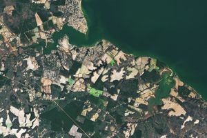

“Smarter” land use planning and better estimates of polluted water runoff acrossthe 64,000 square-mile (110,000-square-kilometer) Chesapeake Bay watershed are onthe horizon thanks to new land cover maps being produced by the Mid-AtlanticRegional Earth Science Applications Center (RESAC) at the University of Maryland.These maps, generated by overlaying images from NASA's Landsat 7, will provide amore precise assessment of the presence and amount of different land cover typesincluding residential development, wetlands, forests and crop lands.
“This type of precise land cover classification has not been done before for suchan extensive region,” said Goetz, university research scientist and RESACmanager. “The new maps can distinguish low-density from high-density residentialdevelopment and crop land from pasture land, as well as wetlands and differenttypes of forest.”
Local and regional planning agencies in the Washington, D.C., area are currentlyworking with the RESAC on the first Landsat 7 maps (above), which are centered on thenation's capital and the surrounding counties in Maryland and Virginia. TheMaryland Department of Planning has said it will use the maps in the state's new"smart growth" initiative, while the parks commission in Montgomery County, Md.,plans to assess the extent of forests in its parks.
For more information, visit the Mid Atlantic Resac web site.
References & Resources
Image courtesy Michelle Thawley, Mid-Atlantic RESAC
None