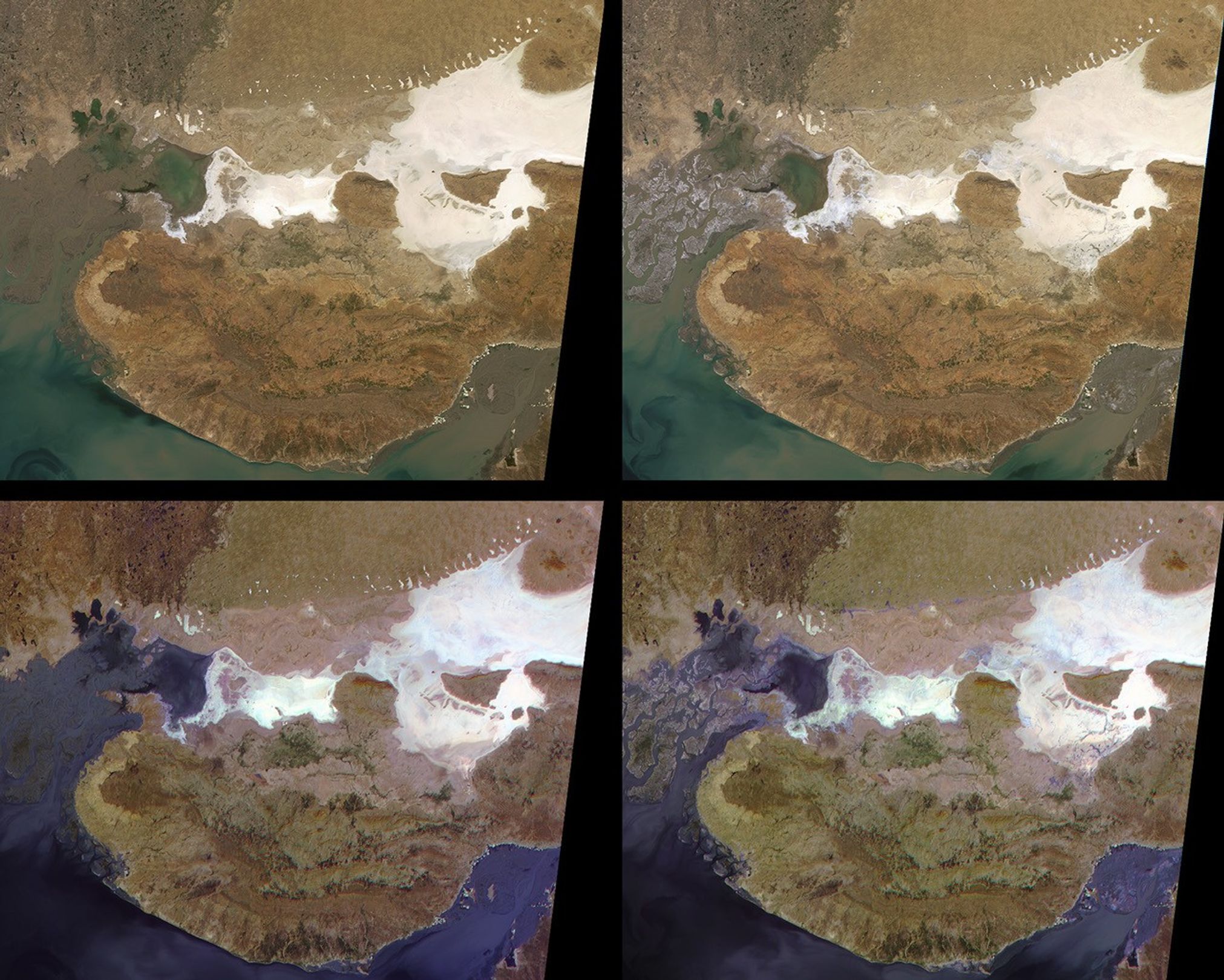
These Multi-angle Imaging Spectroradiometer (MISR) images showthe Kachchh region in the Gujarat province ofwestern India. On January 26, 2001, a magnitude 7.7 earthquakedevastated this area, killing 20,000 people and destroying buildings,dams, and port facilities. The two upper MISR images are pre- andpost-earthquake scenes acquired on January 15 and January 31, 2001,respectively. They are "true-color" imagesmade by combining the red, green and blue bands from the nadir(vertically down-looking) camera. The two lower views are "false-color"images made by combining the red bands from three different cameras.Blue is assigned to the camera pointing 70 degrees forward (moresun-facing), green to the nadir camera, and red to the camera pointing70 degrees aftward. Each of these images is about 275 kilometers wide by218 kilometers high.
The earthquake epicenter was just below the southern tip of the large,white area on the right-hand side of the images, and about 70 kilometersnortheast of the city of Bhuj. The earthquake may have occurred on theKachchh Mainland Fault, which extends from the region of the epicenterwestward along the curved boundary between the darker brown region tothe south and the lighter brown area north of it. The compressivestresses responsible for the earthquake are related to the collision ofIndia with Asia and the resulting rise of the Himalayas to thenortheast.
That part of the Kachchh region which lies north of the Kachchh MainlandFault includes the Banni Plains and the Rann of Kachchh. It is a low,flat basin characterized by salt pans and mud flats. The salt forms inthe Rann of Kachchh as mineral-laden waters evaporate. The salt flatscan be seen in the nadir images as highly reflective, white and grayareas. During the earthquake, strong shaking produced liquefaction inthe fine silts and sands below the water table in the Rann of Kachchh.This caused the mineral grains to settle and expel their interstitialwater to the surface. Field investigations have found abundant evidenceof mud volcanos, sand boils, and fissures from which salty ground watererupted over an area exceeding 10,000 square kilometers. Evidence of theexpelled water can also be seen on the MISR images.
Notice the delicate, dendritic pattern of stream channels throughoutmany of the salt-flats on the post-earthquake image, especially duenorth of the epicenter. These carried water brought to the surface byliquefaction during the earthquake. Areas where shallow surface water ispresent are much easier to see on the false-color multi-angle compositeimages. Wet areas are exhibiting a combination of enhancedforward-scattered light due to the reflection by the water, and enhancedbackward scattering due to surface roughness or the presence ofsediments. This combination results in blue to purple hues.
The region of sand dunes in the upper right and the Indus River valleyand delta in the upper left are inside Pakistan. Near the top of theimages, there is an east-west trending linear feature separating theThar desert of Pakistan from the Rann of Kachchh. This is the NagarParkar Fault. On both pre-earthquake images, this feature is evidentonly from the contrasting brown colors on either side of it. On thepost-earthquake images, a narrow ribbon defines the boundary between thetwo geologic provinces. However, only in the multi-angle composite do wesee evidence that this ribbon may be a water-filled channel. Becausethis area is politically sensitive and fairly inaccessible, no fieldteams have been able to verify liquefaction effects or the presence ofwater there.
References & Resources
Image courtesy NASA/GSFC/LaRC/JPL, MISR Team