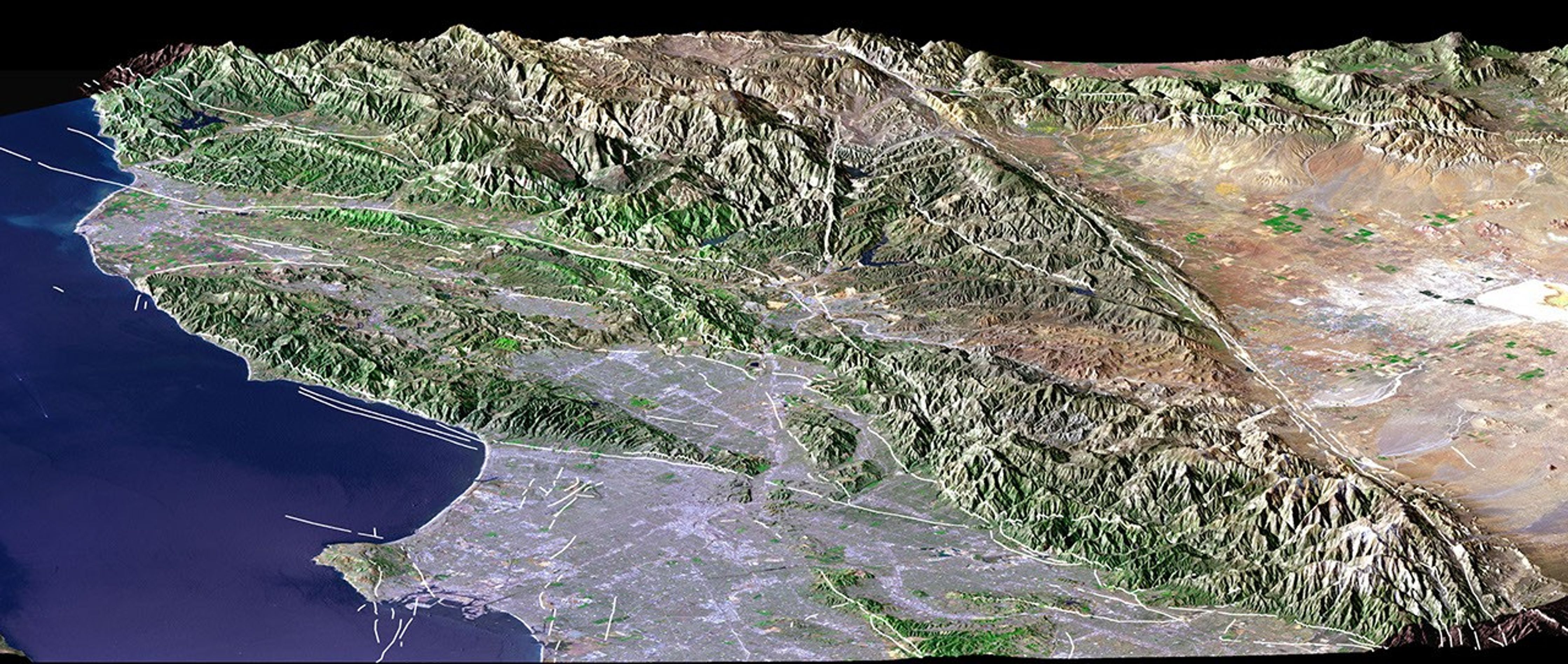
Los Angeles, Calif., is one of the world’s largest metropolitan areaswith a population of about 15 million people. The urban areas mostlycover the coastal plains and lie within the inland valleys. Theintervening and adjacent mountains are generally too rugged for muchurban development. This is in large part because the mountains are#8220;young,” meaning they are still building (and eroding) in thisseismically active (earthquake prone) region.
Earthquake faults commonly lie between the mountains and thelowlands. The San Andreas fault, the largest fault in California,likewise divides the very rugged San Gabriel Mountains from thelow-relief Mojave Desert, thus forming a straight topographic boundarybetween the top center and lower right corner of the image. We presentthis perspective image from NASA’s Shuttle RadarTopography Mission (SRTM) with a graphic overlaythat maps faults that have been active in Late Quaternary times (whitelines). The fault database was provided by the U.S. Geological Survey.
The Landsat image used here was acquired on May 4, 2001, about sevenweeks before the summer solstice, so natural terrain shading is notparticularly strong. It is also not especially apparent given a viewdirection (northwest) nearly parallel to the sun illumination (shadowsgenerally fall on the backsides of mountains). Consequently, topographicshading derived from the SRTM elevation model was added to the Landsatimage, with a false sun illumination from the left (southwest). Thissynthetic shading enhances the appearance of the topography.
Size:View width 134 kilometers (83 miles); view distance 150 kilometers (93 miles)
Location:34.3 degrees North latitude, 118.4 degrees West longitude
Orientation:View west-northwest, 1.8 X vertical exaggeration
Image Data:Landsat Bands 3, 2+4, 1 as red, green, blue, respectively
Original Data Resolution:SRTM 1 arcsecond (30 meters or 98 feet), Landsat 30 meters (98 feet)
Graphic Data:Earthquake faults active in Late Quaternary times Date Acquired: February 2000 (SRTM), May 4, 2001 (Landsat).
References & Resources
Image Courtesy SRTM Team NASA/JPL/NIMA and Landsat 7 Science Team NASA GSFC/USGS