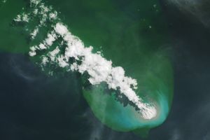
Papua New Guinea’s Manam Volcano released a thin, faint plume on June 16, 2010, as clouds clustered at the volcano’s summit. The Advanced Land Imager (ALI) on NASA’s Earth Observing-1 (EO-1) satellite took this picture the same day.
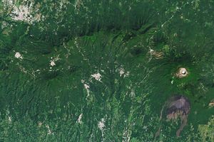
Brown valleys, bare of vegetation, extend downwards from the summit craters. The valley floors are filled with recent lava flows and scoured by hot volcanic avalanches (called pyroclastic flows). The remaining slopes are carpeted in lush tropical vegetation.
The clouds appear to be composed of a mixture of steam emitted by the volcano, and atmospheric water vapor condensing on particles in the volcanic plume. The remaining plume appears as a thin, blue-gray veil extending toward the northwest (upper left) over the Bismarck Sea.
Located 13 kilometers (8 miles) off the coast of mainland Papua New Guinea, Manam forms an island 10 kilometers (6 miles) wide. It is a stratovolcano. The volcano has two summit craters, and although both are active, most historical eruptions have arisen from the southern crater.
References & Resources
- Global Volcanism Program. (n.d.) Manam. Accessed June 21, 2010.
NASA Earth Observatory image created by Jesse Allen, using EO-1 ALI data provided courtesy of the NASA EO-1 team. Caption by Michon Scott.