


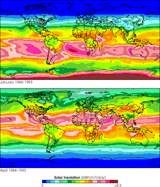
These false-color images show the average solar insolation, or rate ofincoming sunlight at the Earth's surface, over the entire globe for themonths of January and April. The colors correspond to values (kilowatthours per square meter per day) measured every day by a variety of Earth-observing satellites and integrated by the International Satellite Cloud Climatology Project (ISCCP). NASA's Surface Meteorology and Solar Energy (SSE)Project compiled these data--collected from July 1983 to June 1993--into a 10-year average for that period.
Such images are particularly useful to engineers and entrepreneurs whodevelop new technologies for converting solar energy into electricity.To attain best results, most devices for harvesting sunlight require aninsolation of greater than 3 to 4 kilowatt hours per square meter perday. Luckily, insolation is quite high year round near the equator,where roughly a billion people around the world must spend more money onfuel for cooking than they have to spend on food itself. Natural renewableenergy resources is a particularly relevant topic in the United Statestoday as there are rolling blackouts across the state of Californiawhile other U.S. city and state governments grapple with energyderegulation issues.
To facilitate development of new technologies for harvesting naturalrenewable energy sources, the SSEProject at NASA's Langley Research Center has made available a wealth ofglobal-scale data on a variety of meteorological topics, includinginsolation, cloud cover, air temperature, and wind speed and direction.These data are freely available at the SSE Project Web Page.
For more details on the SSE Project, refer to the April 19, 2001, press release issued by NASA LaRC.
References & Resources
Image courtesy Roberta DiPasquale, Surface Meteorology and Solar Energy Project, NASA Langley Research Center, and the ISCCP Project
None


