![Request for Information – Potential [Placeholder for Prize]](https://assets.science.nasa.gov/dynamicimage/assets/science/psd/solar/2023/09/s/solarsystem_0.jpg?w=1024)


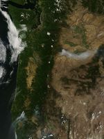
On July 27, 2013, the Moderate Resolution Imaging Spectroradiometer (MODIS) on NASA’s Terra satellite captured this image of the Mile Marker 28 fire burning about 15 miles northeast of Goldendale, Washington. Red outlines indicate hot spots where MODIS detected unusually warm surface temperatures associated with fire. The lower image, a photograph taken by a firefighter on the Washington Incident Management Team 2, shows a column of smoke billowing from the blaze on July 28.
A total of 2,205,000 acres (892,331 hectares) had burned during the 2013 wildfire season in the United States by July 26, 2013, according to the National Interagency Fire Center. Over the past ten years, the average number of U.S. acres burned by July 26 was significantly higher—3,977,074 acres (1,609,465 hectares).
Further Reading
- Inciweb (2013, July 29) Mile 28 Marker Fire. Accessed July 29, 2013.
- National Interagency Fire Center (2013, July 29) Year-to-date Statistics. Accessed July 29, 2013.
- Tri-City Herald (2013, July 28) Goldendale wildfire up to nearly 27 square miles. Accessed July 29, 2013.
References & Resources
NASA image courtesy Jeff Schmaltz, LANCE/EOSDIS MODIS Rapid Response Team at NASA GSFC. Caption by Adam Voiland.