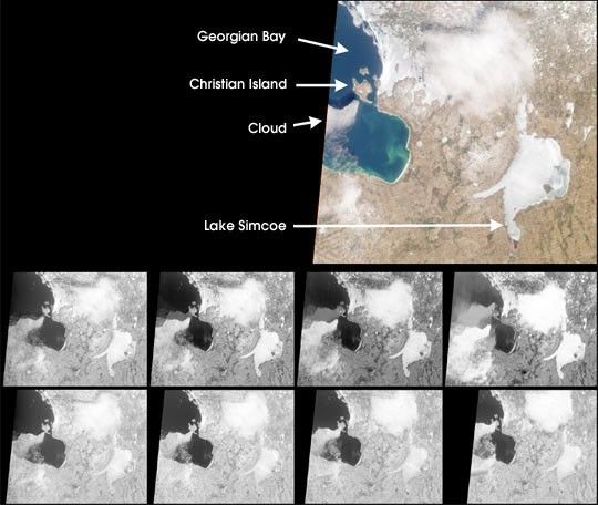
MISR images of the southeast portion of Georgian Bay in Ontario, Canada,acquired on March 6, 2000, during Terra orbit 1155. The color image isfrom the nadir (vertical) camera, and highlights a cloud to thesouthwest of Christian Island. In this view, the shadow cast by thecloud on the water is visible just north of the cloud itself. Brightareas in the image are either cloud or ice; an example of the latter isthe frozen Lake Simcoe.
The eight monochrome images are red band data from the off-nadircameras. Starting with the one in the upper right and movingcounterclockwise, the images progress from the most forward-viewing tothe most aftward-viewing camera. Thus, the top (bottom) row ofmonochrome images are views acquired forward (aftward) of vertical. Theapparent displacement of the cloud from south to north as the viewprogresses from forward to aftward is primarily a geometric parallaxeffect due to the cloud's elevation above the surface.
In each image in the top row, a fainter feature with the same shape asthe cloud is visible within Georgian Bay. The feature and the clouditself approach one another as the view angle becomes less oblique. Thefeature is present only in the water, and disappears over the landsurface of Christian Island. What is it?
We are observing reflections of the cloud in the water. Their positionsare dictated by the law of reflection, which states that the anglerelative to the vertical of the reflected rays is the same as the angleof the incident rays. Therefore, the apparent location of a reflectionrelative to the cloud changes as a function of camera view angle. Unlikewater, land does not act as a good mirror. Also, in the aftward viewsthe reflections are less visible because they are blocked by thesouthern extension of the cloud. Reflections of this sort are notvisible in conventional vertical imagery because in that case they liedirectly underneath the cloud, and are consequently obscured.
MISR was built and is managed by NASA's Jet Propulsion Laboratory,Pasadena, CA, for NASA's Office of Earth Science, Washington, DC. TheTerra satellite is managed by NASA's Goddard Space Flight Center,Greenbelt, MD. JPL is a division of the California Institute ofTechnology.
For more information: http://www-misr.jpl.nasa.gov
References & Resources
Image by NASA/GSFC/JPL, MISR Science Team