


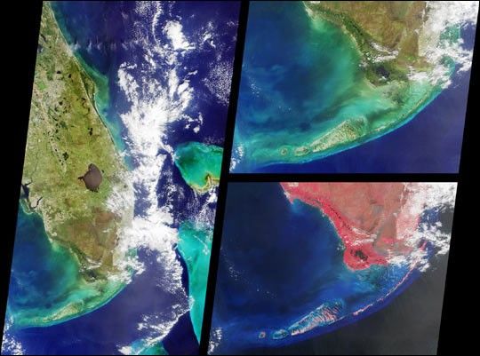
These Multi-angle Imaging Spectroradiometer (MISR) nadir-camera images of southern Florida were acquired onOctober 18, 2000. The view on the left includes Daytona Beach near thetop and the Florida Keys at the bottom. Orlando appears as a grayishpatch near the top of the image, just to the east of the greenish LakeApopka, Florida's fourth largest and most polluted lake. On the coast isCape Canaveral, home of the Kennedy Space Center.
The large body of water in the middle of the land area is LakeOkeechobee.On the western (Gulf of Mexico) coast, Charlotte Harbor and FortMyers are visible. Along the eastern (Atlantic) coast, partiallyobscured by clouds, are Palm Beach, Fort Lauderdale, and Miami.Further to the east, the shallow waters and reefs of the LittleBahama and Great Bahama Banks appear in striking blue and green colors.
The two righthand images show the Florida Everglades and theKeys in more detail. Like the lefthand view, the top image is anatural color composite of blue, green, and red band imagery.On the bottom is a false color composite comprised of green,red, and near-infrared data. Near-infrared light is invisible tothe human eye. The high reflectance of plants in this part ofthe electromagnetic spectrum, displayed here in shades ofred, is the basis of many satellite-based techniques fordetecting and characterizing land surface vegetation.
References & Resources
Image courtesy NASA/GSFC/JPL, MISR Team


