


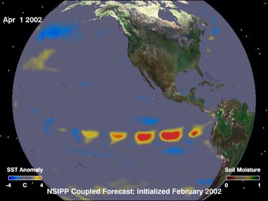
What will climate conditions around the world be like for the rest of this year?Some researchers are predicting an El Niño will arrive in the spring of 2002.The false-color image above represents a one-day snapshot of what conditionswill be like on April 1, 2002, as predicted by a sophisticated NASA computer model.Developed by NASA’s Seasonal-to-Interannual Prediction Program (NSIPP),this model actually links together three models in one—one each forgeophysical dynamics within the atmosphere, oceans, and lands. Thisanimationshows what the NSIPP model’s predicts global climate conditions willbe like every day for an entire year, starting on Feb. 1, 2002. Please note that these predictions are experimental and are produced for research purposes only. Use of these forecasts for purposes other than research is notrecommended.
In the these images, the colors in the ocean represent changes from averagesurface temperature. Yellow and red pixels show where the model predicts therewill be warmer-than-average temperatures. Light blue and dark blue showscooler-than-average temperatures. Grey indicates the temperatures will remainaverage. The colors on land represent variation in soil moisture. Dark brown huesshow where the mode predicts the soil will be drier than normal and greens showwhere it will be wetter than normal. Again, grey hues indicate an average soilwetness.
As can be seen in the animation, the NSIPP model predicts that while there willlikely be relatively small pockets of warm sea surface temperatures in thetropical Pacific Ocean, the strong prevailing trade winds will continue pushingthese waters westward. The model predicts that the trade winds, coupled withthe strong upwelling of deep, very cold waters off the northwestern coast ofSouth America, will effectively prevent the onset of El Niño.
Understanding and predicting seasonal-to-interannual climate variations isessential in the overall NASA strategy for climate research. The NSIPPprogram uses satellite remote sensing data together with measurements fromfield experiments to develop and refine its computer models. Scientists use thesemodels in a number of international climate research programs in an effort tobetter understand how the Earth’s climate system works. In particular, NSIPPseeks to better understand and predict those climate variations that have socialand economic impacts on the United States.
References & Resources
Image and animation courtesy NASA Seasonal-to-Interannual Pediction Project


