


![Request for Information – Potential [Placeholder for Prize]](https://assets.science.nasa.gov/dynamicimage/assets/science/psd/solar/2023/09/s/solarsystem_0.jpg?w=1024)


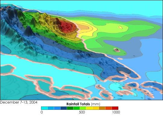
At least eleven people have perished and more than 10,000 have beenevacuated in the worst flooding to hit Malaysia in over a decade. Thehardest hit areas are along the east coast of peninsular Malaysia in thestates of Kelantan, Terengganu and Pahang. The city of Kota Baru wasparticularly hard hit. For Malaysia, December is part of the northeastmonsoon. Prevailing northeasterly winds flow across the South China Seabringing in abundant moisture. Typically, during the northeast monsoon,heavy rain events lasting on the order of a few days are common. Theprevailing winds can interact with the topography squeezing out themoisture.
The TRMM-based, near-real time Multi-satellite Precipitation Analysis (MPA) at the NASA Goddard Space Flight Center monitors rainfall over the global tropics. This image shows the accumulated rainfall between December 7 and December 13, 2004, with respect to the topography of the Malaysian peninsula. The heaviest rainfall is co-located with the eastern slopes of the coastal topography (red area) indicating where the prevailing moisture laden winds interacted with the terrain.
TRMM is a joint mission between NASA and the Japanese space agency JAXA.
References & Resources
Image produced by Hal Pierce (SSAI/NASA GSFC) and caption by Steve Lang (SSAI/NASA GSFC).


