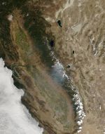
On September 10, 2013, the Moderate Resolution Imaging Spectroradiometer (MODIS) on NASA’s Aqua satellite captured this image of the Morgan fire burning in California, southeast of Clayton. Red outlines indicate hot spots where MODIS detected unusually warm surface temperatures associated with fire. The fire started on September 8, 2013. Two days later, it had burned about 3,200 acres (1,300 hectares) and forced the evacuation of dozens of homes. According to the National Interagency Fire Center, a total of 3.9 million acres (1.6 million hectares) had burned during the 2013 wildfire season in the United States as of September 9. Over the past ten years, the average number of U.S. acres burned by early September was 6.4 million acres (2.6 million hectares).
Further Reading
- Cal Fire (2013, September 10) Morgan fire. Accessed September 10, 2013.
- San Francisco Chronicle (2013, September 9) Fire grows near Mt. Diablo park – homes evacuated. Accessed September 10, 2013.
- National Interagency Fire Center (2013, September 10) Year-to-date Statistics. Accessed September 10, 2013.
References & Resources
NASA image courtesy Jeff Schmaltz, LANCE/EOSDIS MODIS Rapid Response Team at NASA GSFC. Caption by Adam Voiland.