


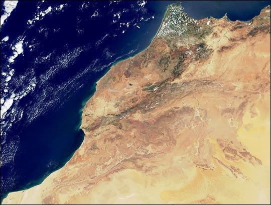
This true-color image over Morocco was acquired on April 23, 2000, byNASA's Moderate-resolution Imaging Spectroradiometer, or MODIS, flyingaboard the Terra spacecraft. The image was produced using a combinationof the sensor's 250-m and 500-m resolution bands. Notice the exquisitedetail in the colors and textures of the variety of land surfacefeatures in northwestern Africa.
The heavily-vegetated (green pixels) peninsula in the top center of theimage is the southern shore of the Strait of Gibralter--the passagebetween the Atlantic Ocean and the Mediterranean Sea. Notice the patchyformation of low-level cumulus clouds (white pixels) over this region,suggesting a moister climate that contributes to better plant growth.On the tip of this peninsula is the coastal city of Tangier.
Moving west along the coastline, the city of Casablanca lies about 200miles (330 km) southwest of Tangier, and about 50 miles south of Rabat,the capital city. Both Casablanca and Rabat are visible as small greyclusters of pixels. About 200 miles due south of Casablanca, the AtlasMountains (brownish pixels) are running in a northeasterly directiontoward Algeria, Morocco's eastern neighbor.
Toward the bottom right side of the image is a portion of thenorthwestern edge of the Sahara Desert. The most yellow pixels towardthe southeast corner of the image is the region in the Sahara known asthe Great Western Erg, in Algeria.
References & Resources
Image courtesy Jacques Descloitres, MODIS Land Group, NASA GSFC


