


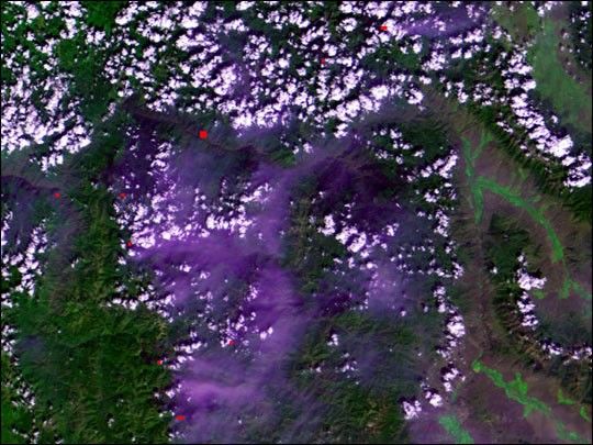

These Multi-angle Imaging Spectroradiometer (MISR) imagesof Zambia and Botswana, Africa were acquired on August25, 2000. The left image is a "true" color viewfrom the vertical-viewing (nadir) camera. True color means that theimages acquired through MISR’s red, green, and blue filters,respectively, are displayed as red, green, and blue when creating thedigital image. The middle image combines data from the green, red, andnear-infrared bands. The right image contains red band data only, but isa composite of imagery from the nadir (An), 70.5-degrees forward (Df),and 70.5-degrees aftward (Da) cameras. The color variations in themulti-angle composite arise not from how the different parts of thescene reflect light at different wavelengths, but rather, at differentangles.
The distinctive fan-like feature on the left of each image is the highlyvegetated Okavango Delta, a mosaicked network of grasslands and waterchannels, observed here during the dry season. The town of Maun is atits southeastern edge. Note how the plant life, which is highlyreflective in the near-infrared, shows up as bright red in the middleimage. Vegetation also preferentially reflects light back toward thesource of illumination, so in the right image, the Df camera image,which is displayed in green, is brighter in this region.
The body of water in the upper right is the Itezhi-Tezhi Dam, fed by theKafue River in Zambia. At the lower left, south of the Okavango Delta,is Lake Ngami. A smoke plume is present at the southern edge of thelake. This plume and others show up in shades of blue and purple in themulti-angle composite as a result of the manner in which the smokeparticles scatter sunlight.
Other landmarks include the Ntwetwe Pan, whose western edge is visibleas the bright area in the lower right. The Zambezi River enters from theupper left and wends its way southeast, passing the Caprivi Strip, anarrow panhandle in northeast Namibia. The greater abundance ofvegetation here testifies to the high rainfall that occurs during thewet season. Near the right-hand edge of the images is the location wherethe Zambezi plunges into Victoria Falls, considered to be among the mostspectacular waterfalls in the world.
References & Resources
Image by NASA/GSFC/JPL, MISR Science Team


