


The Namib Desert in southwestern Africa is considered the oldest desert on Earth. It also gives rise to some of the planetâs tallest dunes.
Many of the highest dunes are found within the Namib Sand Sea, a section of the desert that spans 34,000 square kilometers (13,000 square miles) of coastal Namibia. The sand sea and its dunes are visible in this image, acquired on January 20, 2020, with the HawkEye sensor on the SeaHawk CubeSat.
Most of the sand originated from erosion processes that occur to the south of this image, near the Orange River valley. The Orange River carries sandy sediment into the Atlantic Ocean, and then northward flowing currents move it along the coast and deposit it along the shore. Strong prevailing winds out of the south also can pick up sand and deliver it to the sand sea.
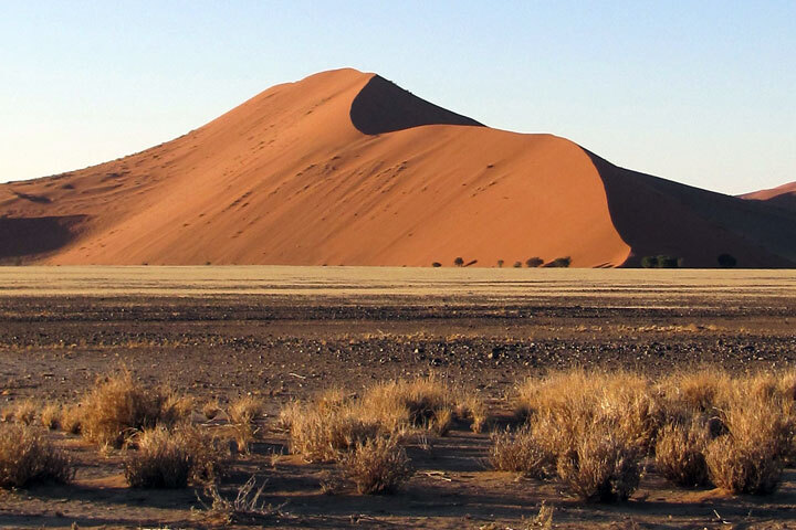
Sculpted by winds, the dunes are visible throughout the sand sea. Crescent (barchan) dunes appear closest to the shore and are shaped by onshore winds. Farther inland, linear dunes dominate, interrupted in places by patches of star dunes shaped by wind blowing from all directions. Dune 45, visible in the detailed image above and the photograph below, is an example of a star dune. Composed of 5-million-year-old sands, Dune 45 towers 80 meters (260 feet) over the desert floor on the eastern flank of the sand sea.
Other large dunes—including the sand sea’s tallest, a 325-meter (1,065-foot) dune nicknamed Big Daddy—line the bed of the Tsauchab River. The Tsauchab originates in the Naukluft Mountains, then cuts across the sand sea before coming to an end at Sossusvlei, a salt and clay pan about 40 kilometers (25 miles) from the sand sea’s eastern flank. Like most rivers and streams in the region, the Tsauchab is ephemeral. Water tends to flow in the Tsauchab and pool up in Sossusvlei every few years or so, generally after a rare heavy rainstorm. In the 2020 view above, the riverbed and clay pans are dry. White areas are likely salt.
Still, life has found a unique way to survive even without much rain. Fog is the primary source of water for the Namib Sand Sea, which is the only coastal desert in the world to contain large dune fields influenced by fog. This moisture results in relatively abundant and diverse vegetation, particularly on the rocky hills or mountains (inselbergs) that rise above the desert.
References & Resources
- Brook, G. A. et al. (2006) Characteristics and OSL minimum ages of relict fluvial deposits near Sossus Vlei, Tsauchab River, Namibia, and a regional climate record for the last 30 ka. Journal of Quaternary Science, 21, 347â362.
- Feder, A. et al. (2018) Fluvial-aeolian sedimentary facies, Sossusvlei, Namib Desert. Journal of Maps, 14 (2), 630â643.
- The Geography Teachers Association of NSW & ACT Inc. (2018) Namib Desert. Accessed November 24, 2021.
- Lancaster, N. (1983) Controls of Dune Morphology in the Namib Sand Sea. Developments in Sedimentology, 38, 261â289.
- NASA Earth Observatory (2020, January 13) Sandscapes of the Namib Desert.
- NASA Earth Observatory (2020, January 2) Where the Dunes End.
- NASA Earth Observatory (2018, July 5) Between the Ripples of the Namib Sand Seaf.
- NASA Ocean Color Selected HawkEye Scenes. Accessed November 24, 2021.
- Vermeesch, P. et al. (2010) Sand residence times of one million years in theNamib Sand Sea from cosmogenic nuclides. Nature Geoscience, 3, 862â865.
- Wikipedia Sossusvlei. Accessed November 24, 2021.
- World Heritage Datasheet Namib Sand-sea. Accessed November 24, 2021.
NASA image by Alan Holmes/ NASA’s Ocean Color Web , using data from SeaHawk/HawkEye . Photo courtesy of pxfuel. Story by Kathryn Hansen .


