


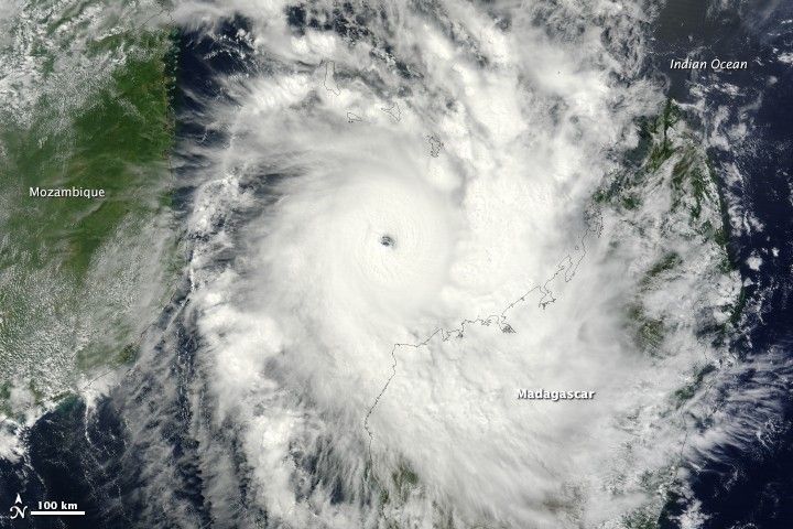
On Sunday, March 30, 2014, the outlook appeared grim for cities in northwestern Madagascar. Tropical cyclone Hellen spun offshore, gaining strength with surprising rapidity and with a track destined to bring it ashore. The day started with the storm being the equivalent of a Category 2 storm with winds of 170 kilometers per hour (100 miles per hour or 90 knots). Twelve hours later, winds reached 240 kilometers per hour (150 miles per hour or 130 knots), making it a strong Category 4 storm.
The Moderate Resolution Imaging Spectroradiometer (MODIS) on NASA’s Terra satellite acquired this image of Cyclone Hellen at 7:20 UTC on March 30 in the middle of the storm’s rapid intensification. The storm had a distinct open eye and a classic tight circular shape. Its outer bands were already over northwestern Madagascar.
The rapid intensification prompted the Regional Specialized Meteorological Center (a branch of the French meteorology agency, Meteo France), to warn residents to prepare for a “worst case scenario.” The March 30 warning also said, “Hellen is likely to be one of the most powerful tropical cyclones ever seen over the Northern Channel since the satellite era (1967).“ With clockwise-blowing winds that pushed a mound of water towards the southeastern side of the storm, Hellen was likely to bring a strong storm surge as high as 7 meters (23 feet) to the coast of Madagascar.
Fortunately, Hellen weakened substantially not long before it made landfall, minimizing the damage. Just before landfall, warning bulletins advised residents to prepare for periods of heavy rain and wind and a possible storm surge of 2 meters (7 feet). An early assessment from the UN Office for the Coordination of Humanitarian Affairs indicates that approximately 170 homes were destroyed and just over 900 people evacuated in Madagascar.
References & Resources
- Regional Specialized Meteorological Center (2014, March 31) Warning number 14/14/20132014. Accessed April 4, 2014.
- Regional Specialized Meteorological Center (2014, March 30) Warning number 12/14/20132014. Accessed April 4, 2014.
- UN Office for the Coordination of Humanitarian Affairs. (2014, April 2) Thousands affected in Comoros and Mozambique; alerts lifted in Madagascar. Accessed April 4, 2014.
- Unisys Weather (2014, April 1) Cyclone-4 Hellen. Accessed April 4, 2014.
- The Weather Channel (2014, March 31) Tropical Cyclone Hellen: Worst case scenario avoided in Madagascar. Accessed April 4, 2014.
NASA image courtesy Jeff Schmaltz, LANCE/EOSDIS MODIS Rapid Response Team at NASA GSFC. Caption by Holli Riebeek.


