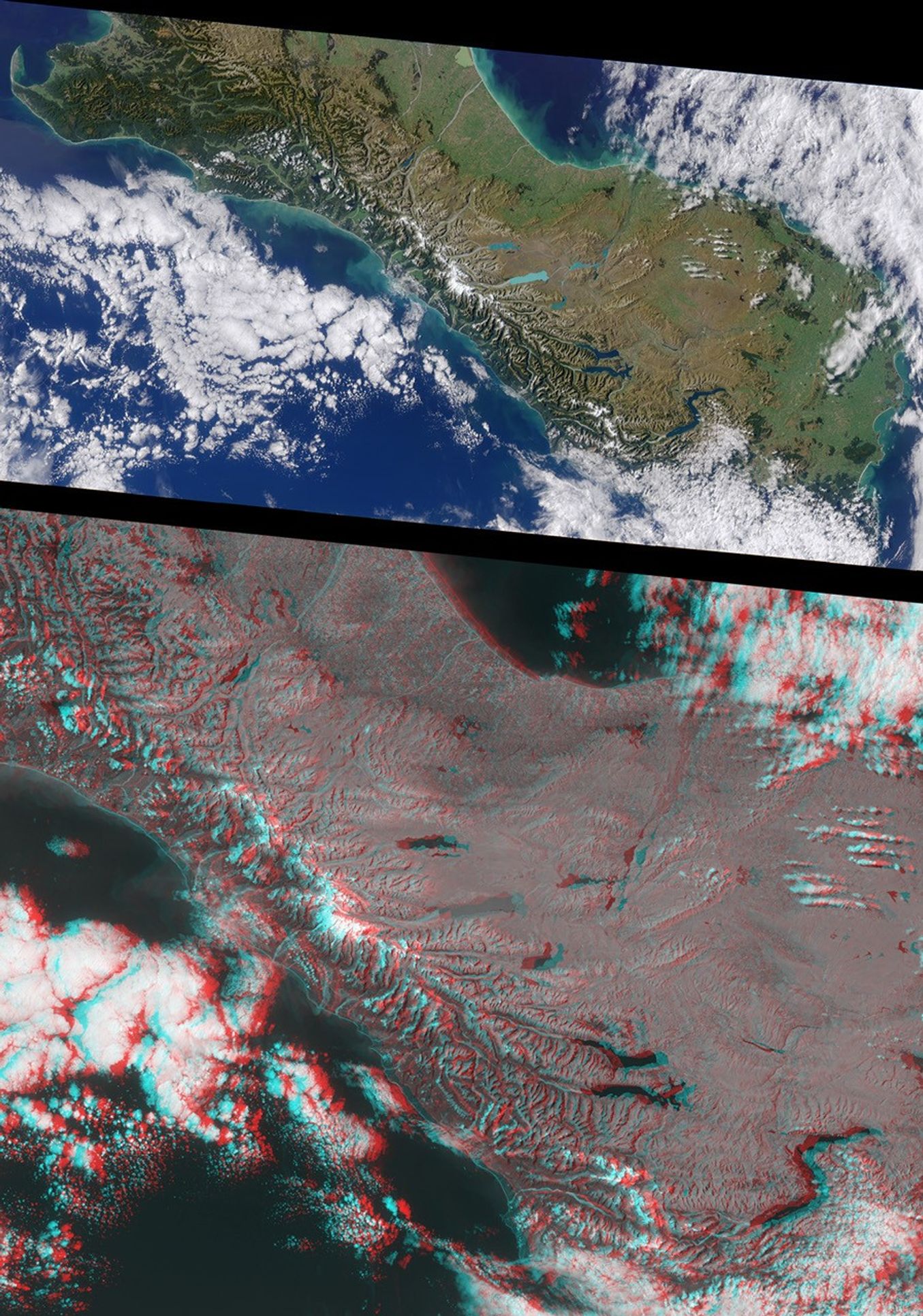


The rugged Southern Alps extend some 650 kilometers (400 miles) along the westernside of New Zealand's South Island. The mountains are often obscured byclouds, which is probably why the Maoris called New Zealand "Aotearoa",the long white cloud. The higher peaks are snow-covered all year round.Westerly winds bring clouds that drop over 500 centimeters (195 inches) of rainannually on luxuriant rain forest along the west coast. The driereastern seaboard is home to the majority of the island's population.
This pair of Multi-angle Imaging Spectroradiometer (MISR) images is from April 13, 2000. Theupper image is a natural color view from the instrument'svertical-viewing (nadir) camera. It is presented at a resolution of 550meters (1800 feet) per pixel. The lower image is a stereo anaglyph generated fromthe instrument's 46-degree and 26-degree forward-viewing cameras, and ispresented at 275-meter (900 feet) per pixel resolution to show the portion of theimage containing the Southern Alps in greater detail. Viewing theanaglyph in 3-D requires the use of red/blue glasses with the red filterover your left eye. To facilitate stereoscopic viewing, both images havebeen oriented with north at the left.
The tallest mountain in the Southern Alps is Mt. Cook, at an elevationof 3754 meters (12287 feet). Its snow-covered peak is visible to the left of centerin each of these MISR images. From the high peaks, glaciers have gougedlong, slender mountain lakes and coastal fiords. Immediately to thesoutheast of Mt. Cook (to the right in these images), the glacialpale-blue water of Lake Pukaki stands out. Further to the south inadjacent valleys you can easily see Lakes Hawea and Wanaka, betweenwhich (though not visible here) is the Haast Pass Road, the mostsoutherly of the few links between the east and west coast road systems.Further to the south is the prominent "S" shape of Lake Wakatipu, 83kilometers (52 miles) long, on the northern shore of which is Queenstown, theprincipal resort town of the island. The remote and spectacularFiordland National Park, which occupies the far southwest of the island,is largely under cloud.
Prominent along the east coast are the Canterbury Plains, approximately180 kilometers (110 miles) long and extending inland from the coast to the foothillsof the Southern Alps. This is the largest area of flat land in NewZealand, and a rich agricultural region renowned for its wheat, wool,and livestock. Here the distance between the east and west coasts islittle more than 150 kilometers (90 miles).
References & Resources
Image courtesy NASA/GSFC/LaRC/JPL, MISR Team.