


Tropical Storm Nicole continued to strengthen as the late-season tropical cyclone passed over the Bahamas on November 9, 2022, and then aimed at Florida. Parts of Florida’s east coast were expected to see the strongest winds, but the large size of Nicole’s cloud bands suggests that the storm’s effects could be far-reaching.
The Visible Infrared Imaging Radiometer Suite (VIIRS) on the Suomi NPP satellite captured this natural-color image at about 1 p.m. Eastern Standard Time (18:00 Universal Time) on November 8, 2022. At the time, the storm was located 310 miles (500 kilometers) northeast of the northwestern Bahamas and carried sustained winds of 60 miles (95 kilometers) per hour.
The tropical storm reached the northwestern Bahamas by around midday on November 9. Forecasters called for Nicole to intensify to hurricane strength before reaching southeast or east-central Florida later that night. But given the storm’s vast size, forecasters cautioned that hazardous conditions would extend well beyond the hurricane’s direct path. Dangerous storm surge was expected along coastal Florida and Georgia, while heavy rainfall was expected across much of the Florida Peninsula—bringing even more water to places still recovering from flooding caused by Hurricane Ian in late September.
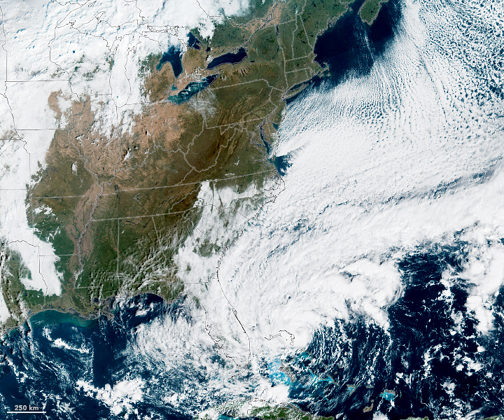
Nicole’s large size is apparent in this simulated natural-color image, acquired at 10 a.m. Eastern Standard Time (15:00 Universal Time) on November 9, 2022, by the Advanced Baseline Imager (ABI) on the Geostationary Operational Environmental Satellite 16 (GOES-16). The satellite is operated by the National Oceanic and Atmospheric Administration (NOAA); NASA helps develop and launch the GOES series of satellites. At the time of this image, Nicole was located 210 miles (340 kilometers) east of West Palm Beach, Florida, and had sustained winds of 70 miles (110 kilometers) per hour.
After making landfall in Florida, forecasters expect Nicole to weaken and turn northward. Heavy rains and gusty winds will likely affect the U.S. Southeast, Mid-Atlantic, and Northeast as the storm’s remnants track north through the remainder of the week.
The Atlantic hurricane season officially runs from June 1 to November 30, although hurricanes can happen outside of these months.
References & Resources
- National Hurricane Center (2022, November 9) Tropical Storm Nicole Discussion Number 10. Accessed November 9, 2022.
- National Hurricane Center (2022, November 8) Tropical Storm Nicole Intermediate Advisory Number 6A. Accessed November 9, 2022.
- Orlando Sentinel (2022, November 9) Will Tropical Storm Nicole hit Orlando? Accessed November 9, 2022.
- The Washington Post (2022, November 9) Where will Nicole hit hardest? Here’s the outlook for 13 cities. Accessed November 9, 2022.
NASA Earth Observatory images by Lauren Dauphin, using VIIRS data from NASA EOSDIS LANCE , GIBS/Worldview , and the Suomi National Polar-orbiting Partnership and GOES 16 imagery courtesy of NOAA and the National Environmental Satellite, Data, and Information Service (NESDIS). Story by Kathryn Hansen .


