
In the Andes Mountains, along the border between Chile and Argentina, lies Llullaillaco Volcano. With an elevation of 6,739 meters (22,109 feet) above sea level, the volcano is the world’s second-highest active volcano after Nevados Ojos del Salado, farther south in the Andes. Llullaillaco’s last recorded eruption occurred in 1877.
Llullaillaco is a stratvolcano composed of alternating layers of hardened lava, solidified ash, and rocks ejected by earlier eruptions. The volcano sits atop an older volcano that collapsed about 150,000 years ago. Viscous, thick lava flows from Llullaillaco have formed visually stunning structures known as coulées.
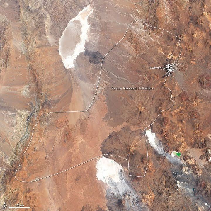
Llullaillaco Volcano has lent its name to a national park in Chile—Parque Nacional Llullaillaco—which extends west and south of the volcano. The Enhanced Thematic Mapper Plus on the Landsat 7 satellite acquired this natural-color image of the park on February 4, 2003. Park boundaries are outlined in white.
Some snow and ice linger on the slopes of Llullaillaco, but little vegetation appears in this landscape. The clearest patch of green occurs in a lake east of the park. This landscape is a combination of mostly bare peaks and salt pans—the large, nearly white areas south and west of the volcano.
Llullaillaco lies along the eastern margin of the Atacama Desert, one of the driest places on Earth. Though there were some recent snowfalls in the area, precipitation is rarely recorded in many parts of the Atacama. Pockets of plants do eke out a living in the region, especially where steep mountains block the movement of fog and allow moisture to collect. The plants provide food for local herbivores, and Parque Nacional Llullaillaco is home to guanacos and vicuñas.
Llullaillaco is also an important archaeological site. In 1999, three Inca mummies were recovered from the summit, having been well preserved by cold, dry conditions.
References & Resources
- Global Volcanism Program. Llullaillaco. Smithsonian Institution. Accessed September 30, 2011.
- GoChile. (2011). Llullaillaco National Park. Accessed September 30, 2011.
- Grady, D. (2007, September 11). In Argentina, a museum unveils a long-frozen maiden. The New York Times. Accessed September 30, 2011.
- Hogan, C.M., World Wildlife Fund. 2011, April 19). Atacama Desert. The Encyclopedia of Earth. Accessed September 30, 2011.
- Klemetti, E. (2010, March 31). Coulées! Eruptions. Accessed September 30, 2011.
- Richards, J.P., Villeneuve, M. (2001). The Llullaillaco volcano, northwest Argentina: construction by Pleistocene volcanism and destruction by sector collapse. Journal of Volcanology and Geothermal Research, 105(1–2), 77–105.
- Stefanov. W. (2010, March 29). Llullaillaco Volcano, Argentina-Chile Border. Earth Observatory. Accessed September 30, 2011.
- Vesilind, P.J. (2003, August). The driest place on Earth. National Geographic. Accessed September 30, 2011.
NASA Earth Observatory image created by Robert Simmon, using Landsat data provided by the United States Geological Survey. Caption by Michon Scott.