


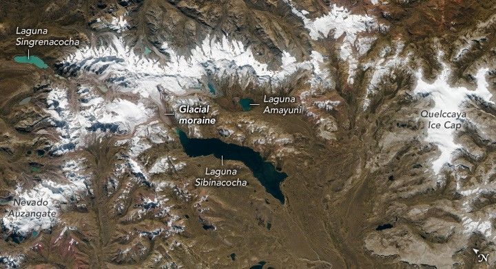
While in orbit over the Andes Mountains in southern Peru, an astronaut aboard the International Space Station photographed the Vilcanota mountain range punctuated with glaciers and alpine lakes. The range hosts the second-largest glaciated mountain region in Peru.
The dark blue hues of Laguna Sibinacocha contrast with bright ice and snow on the upper reaches of the mountains, while smaller glacial lakes, such as Lagunas Singrenacocha and Amayuni, display light blue to blue-green shades. Moraines mark the historical paths of glaciers that feed the lakes. Laguna Sibinacocha stretches approximately 18 kilometers (11 miles) at its longest, and its water ultimately flows into the Amazon River.
Some of the “rainbow mountains,” identifiable by peaks that appear tinged red, can be seen in the bottom left of the image, south of Nevado Auzangate. The varying hues of the mountains result from millions of years of erosion and weathering. These mountains are culturally significant to the local population and have become a well-known tourist attraction due to their unique colors.
The ice-capped mountains and glaciers in this image are known as low-latitude or tropical glaciers, formed initially during the last ice age. Though located in the tropics, these ranges retain permanent ice year-round because of the low temperatures at high altitudes. The neighboring Quelccaya Ice Cap is the world’s largest tropical ice cap.
Glaciers in the tropics are at risk of disappearing due to rising temperatures associated with climate change. Astronauts have collected imagery of glaciers worldwide for decades, documenting changes such as the recession of glacial tongues.
References & Resources
Astronaut photographs ISS069-E-16604–16613 were acquired on May 31, 2023, with a Nikon D5 digital camera using a focal length of 400 millimeters. It is provided by the ISS Crew Earth Observations Facility and the Earth Science and Remote Sensing Unit, Johnson Space Center. The image was taken by a member of the Expedition 69 crew. The image has been cropped and enhanced to improve contrast, and lens artifacts have been removed. The International Space Station Program supports the laboratory as part of the ISS National Lab to help astronauts take pictures of Earth that will be of the greatest value to scientists and the public, and to make those images freely available on the Internet. Additional images taken by astronauts and cosmonauts can be viewed at the NASA/JSC Gateway to Astronaut Photography of Earth. Caption by Sara Schmidt, GeoControl Systems, JETS Contract at NASA-JSC.


