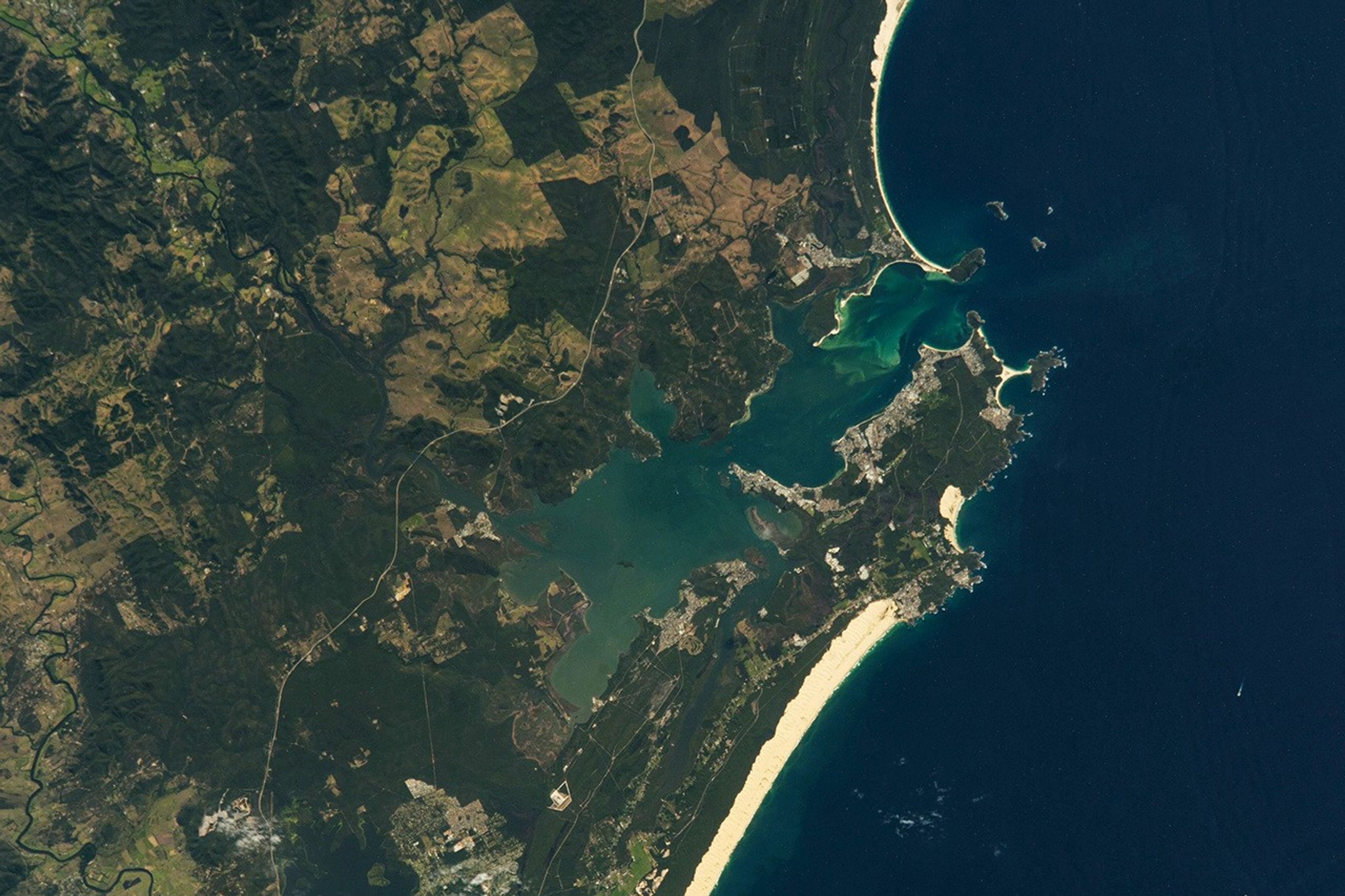


An astronaut aboard the International Space Station took this photograph of Port Stephens Bay in New South Wales along the southeastern coast of Australia. The bay, named in 1770 by Captain Cook, is located 160 kilometers (100 miles) north of Sydney.
Port Stephens is a diverse area that includes towns, beaches, bays, and two types of forests—temperate forests and mangrove forests. Several towns are visible in this image, the largest of which is Nelson Bay. The area is the traditional home of the Worimi, an Aboriginal nation, and contains many culturally significant sites.
Mangrove forests are supported by the wetland environments along the Karuah River and Branch River. Temperate forests, visible as dark green patches, are protected within national parks such as Worimi National Park, where the squirrel glider is designated as a threatened species.
Port Stephens Bay is an estuarine system due to the exchange of water and sediment between the Karuah and Branch rivers with the Pacific Ocean. About 1 kilometer offshore of Yacaaba Head are the Cabbage Tree and Boondelbah Islands. These islands include the 36 hectare (89 acre) John Gould Nature Reserve that provides breeding habitat for the Gould’s petrel, a rare endemic seabird.
The waters within Port Stephens Bay and the nearby coastline are protected within the Port Stephens Great Lakes Marine Park. This marine park provides sanctuary and habitat protection for animals like the humpback whales that migrate across the Pacific Ocean from their feeding grounds in the Antarctic to breed along the Australian coast. Other animals found in these waters include the black rockcod and the critically endangered greynurse shark.
References & Resources
Astronaut photograph ISS068-E-7494945 was acquired on March 10, 2023, with a Nikon D5 digital camera using a focal length of 200 millimeters. It is provided by the ISS Crew Earth Observations Facility and the Earth Science and Remote Sensing Unit, Johnson Space Center. The image was taken by a member of the Expedition 68 crew. The image has been cropped and enhanced to improve contrast, and lens artifacts have been removed. The International Space Station Program supports the laboratory as part of the ISS National Lab to help astronauts take pictures of Earth that will be of the greatest value to scientists and the public, and to make those images freely available on the Internet. Additional images taken by astronauts and cosmonauts can be viewed at the NASA/JSC Gateway to Astronaut Photography of Earth. Caption by Francesca Filippone, Texas State University, JETS Contract at NASA-JSC.