![Request for Information – Potential [Placeholder for Prize]](https://assets.science.nasa.gov/dynamicimage/assets/science/missions/a-step/FFR_Earth_Background_20251120%20.png?w=1024)


Oregon and Washington State suffered the worst windstorm in a decade on December 14, 2006. Winds as high as 180 kilometers per hour (113 miles per hour) were recorded on Mount Rainer, according to the Associated Press, and a new observed wind speed record of 110 km/hr (69 mph) was registered at Seattle-Tacoma International Airport. The winds took out power lines, leaving 240,000 customers without power through the weekend. As of Monday, December 18, ten people had died from causes related to the storm, and at least one hundred had developed carbon monoxide poisoning symptoms, caused by using portable generators for electricity and charcoal grills to cook without adequate ventilation.
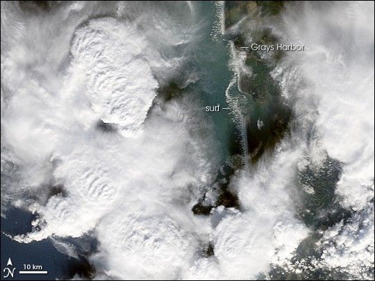
This photo-like image was acquired by the Moderate Resolution Imaging Spectroradiometer (MODIS) on the Terra satellite on December 15, 2006, at 11:10 a.m. local time (19:10 UTC). The small image above shows a close-up section of the Washington coastline just north of the mouth of the Columbia River centered on the inlet of Greys Harbor. Large powerful thunderstorms dominate the scene, with cloud towers projecting up above the surrounding cloud deck where strong updrafts are lifting moist ocean air, a signature of powerful thunderstorms. Along the coast, white dashes show where waves are pounding the shoreline. It is rare for surf to be so dramatic and large that it can be discerned even at MODIS’ moderate resolution, in which features smaller than 250 meters are not easily discerned. However, whipped by the powerful winds, the surf was so rough and large that it shows up clearly.
References & Resources
NASA image by Jesse Allen, Earth Observatory, using data provided courtesy of the MODIS Rapid Response Team, Goddard Space Flight Center.