


For more images and animations,see Iceland's Receding Glacier.
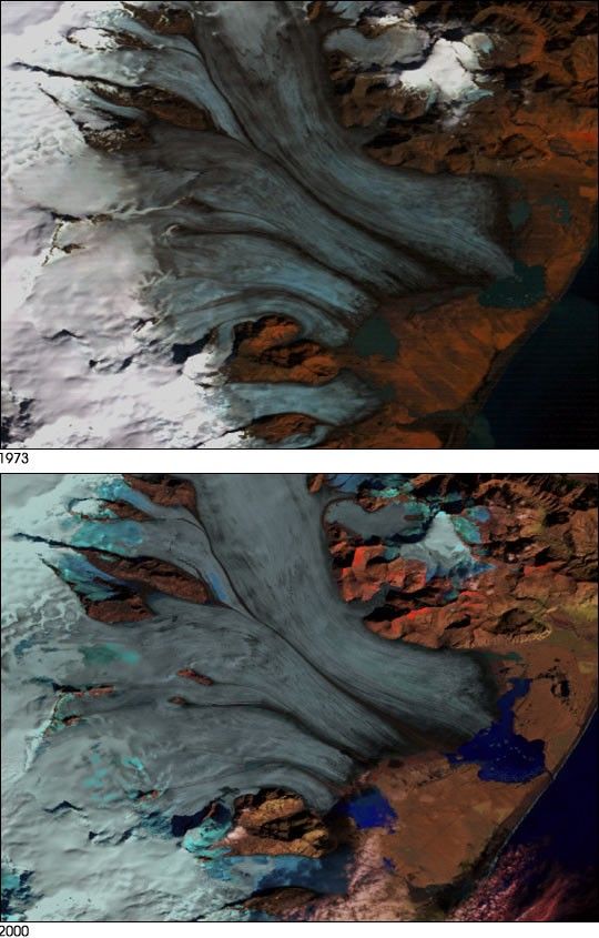
According to NASA glaciologist Dorothy Hall, Landsat data show thatIceland's Breidamerkurjökull has receded by as much as 2 km since1973. The Breidamerkurjökull is an outlet glacier, which is partof Vatnajökull--the largest ice cap in Europe. Hall notes that allbut one of the Vatnajökull's outlet glaciers, roughly 40 namedglaciers in all, are currently receding.
Although all of Iceland's outletglaciers are currently retreating, some glaciers like the Breidamerkurjökull expand and retreatindependent of short-term climate. Therefore,glaciologists must exercise caution when attributing glacier movementsto climate change.
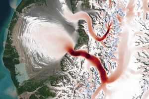
In these false-color composite images, captured by Landsat 1 (in1973) and Landsat 7 (in 2000), the retreat of Breidamerkurjökullcan be seen clearly. As the glacier retreats, you can see the creationof smaller icebergs in the lake formed by the glacier. In these scenes,bare glacier ice surfaces appear bluish-white, while those covered bysnow are bright white. Water surfaces are dark blue and land surfacesappear reddish.
Ground measurements by Icelanders show a somewhat smaller retreat ofthe glacier than do the satellite measurements just west of the lakeJökulsárlón. Ground measurements indicated a1300-meter retreat while satellite measurements showed a 1440-meterretreat. Though the ground measurements are more accurate, Landsat giveswider coverage and fills in the gaps where ground measurements are notperformed.
References & Resources
Images courtesy Dorothy Hall and Janet Chien, NASA Goddard Space Flight Center, and Ron Beck, EROS Data Center Acknowledgements to Richard S. Williams, Jr., U.S. Geological Survey, and Oddur Sigurdsson, National Energy Authority, Iceland
None