


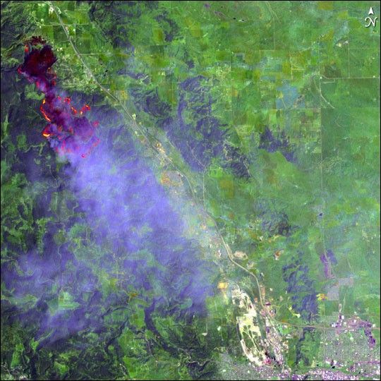
On July 11, 2005, the Ricco Fire in the Black Hills National Forest in South Dakota threatened subdivisions, botanical preserves, and archeological sites. According to the National Interagency Fire Center report from July 15, the fire covered nearly 4,000 acres. The Enhanced Thematic Mapper Plus (ETM+) instrument on the Landsat 7 satellite captured this image of the blaze on July 10, 2005.
This false-color image combines shortwave infrared, infrared, and red wavelengths (ETM+ bands 7, 5, and 3, respectively) to show the dark, forested slopes of the Black Hills National Forest (left) and the brighter green vegetation of the valleys and the grasslands (right). Also visible is the bright red from active flames along the fire fronts, their heat showing up in the shortwave infrared more strongly than in the other wavelengths. The burned area appears in magenta. Smoke hangs over Rapid City, in the lower right corner of the image, along the eastern edge of the forested mountains.
News reports indicate that the Ricco Fire has since been completely contained. On July 14, 2005, Rapid City saw skies clear of smoke for the first time in days.
References & Resources
NASA image provided courtesy of National Center for Earth Resources Observation & Science (NCEROS)


