


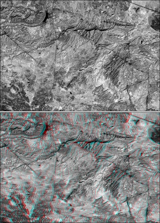
These two images are two-dimensional (top) and three-dimensional(bottom) views of the same area, southeast of Bhuj, India. Together theydemonstrate how NASA's Shuttle Radar Topography Mission (SRTM) elevationmodels can be used to help in the interpretation of satellite imagery.The image was acquired by the Landsat 7 satellite. The top view is astandard panchromatic (visible and near infrared) satellite picture. Thebottom view is the same scene projected into an anaglyph, based uponSRTM data. Anaglyphs are generated by creating two differingperspectives of a single satellite image, one perspective for each eye.
Note that there are several dark lines crossing parts of the image. Someof these lines are roads but some are geologic dikes. Dikes aresheet-like rocks formed when volcanic fluids intrude cracks in olderhost rocks. The intersections of these "sheets" with the topographicsurface appear as linear or curvilinear traces across the terrain. Thedikes traverse varied terrains and they intersect each other--much likeroads. In the two-dimensional view, roads and dikes are confusinglysimilar in appearance. However, in three dimensions, dikes can be seento be ridge-forming features and geographically related to othergeologic features (left and lower right of image). In contrast, roadsgenerally traverse less rugged terrain and pass through ridge gaps(upper right and left center of image). Thus the added topographicinformation provided by SRTM greatly helps in the image interpretation.
The stereoscopic effect of this anaglyph was created by first draping aLandsat satellite image (taken just two weeks after the earthquake) overpreliminary digital elevation data from the Shuttle Radar TopographyMission (SRTM), and then generating two differing perspectives, one foreach eye. When viewed through special glasses, the result is avertically exaggerated view of the Earth's surface in its full threedimensions. Anaglyph glasses cover the left eye with a red filter andcover the right eye with a blue filter.
Landsat has been providing visible and infrared views of the Earth since1972. SRTM elevation data matches the 30-meter (33-yard) resolution ofmost Landsat images and will substantially help in analyses of the largeand growing Landsat image archive. The Landsat 7 Thematic Mapper imageused here was provided to the SRTM project by the United StatesGeological Survey, Earth Resources Observation Systems (EROS) DataCenter, Sioux Falls, South Dakota.
Size: 13.8 x 9.6 kilometers ( 8.6 x 5.9 miles)
Location: 23.2 deg. North lat., 69.8 deg. East lon.
Orientation: North toward the top
Image Data: Landsat Panchromatic Band (visible and near infrared)
Date Acquired: February 2000 (SRTM), February 9, 2001 (Landsat)
References & Resources
Image courtesy NASA/JPL/NIMA


