Search the Earth Observatory
You may search using a text query below, select the topics you wish to browse on the left, or use the two together to refine your search.
All Earth Observatory Topics

Set amid El Salvador’s modern, active volcanic landscape, tranquil blue waters fill a caldera formed by ancient eruptions.

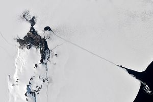
As Iceberg A-23A disintegrated, it shed meltwater that helped fuel an extensive phytoplankton bloom in the South Atlantic Ocean.

A NASA luminary from the Apollo era grew up in Wales near Llanfairpwllgwyngyllgogerychwyrndrobwllllantysiliogogogoch.

Oklahoma’s Salt Plains National Wildlife Refuge attracts rare and diverse species—and enthusiasts looking for a distinct type of crystallized gypsum.

The National fire has burned tens of thousands of acres within the Florida preserve, fueled by vegetation dried by prolonged drought and killed by recent frost.

The hill-shaped features are a sign of explosive volcanic activity—a rarity on the Red Planet.

Nearly 50 years ago, the first Landsat satellite captured the rare sight of Mid-Atlantic waterways frozen over.

Villages and farmland were swamped after unusually heavy early-February rains pushed the Sinú River over its banks.

Satellite-based radar images show where a powerful earthquake in the Yukon, Canada, sent rock, snow, and ice spilling across the frozen landscapes of the St. Elias Mountains.

Winds blowing past the volcanic landmass near the Korean Peninsula created a trail of spiraling clouds, while murky water churned nearby.

A cold snap in the southern U.S. stirred up a dazzling display of sediment in coastal waters.

Dry, gusty conditions spurred fast-growing fires in Oklahoma and Kansas, along with dangerous dust storms across the region.

A vivid display of the aurora lit up skies over the Denmark Strait and eastern Canada during a minor geomagnetic storm in February 2026.

Widespread flooding affected tens of thousands of people after cyclones Fytia and Gezani drenched the island.

The Tongan volcano expanded its mid-Pacific real estate during its latest eruptive phase.
George Washington was born along this tidal creek in Virginia and, as a teenager, made one of his first surveying maps of the surrounding lands.

The glacier in southeastern Svalbard pulses with the changing seasons, speeding up and slowing its flow toward the sea.
An ecologist, a volcanologist, and a chemist walk into a forest… it sounds like the beginning of a bad joke, but this very real collaboration between scientists from NASA and the Universidad de Costa Rica (University of Costa Rica) continues decades of cross-disciplinary…
Cortina d'Ampezzo, flanked by steep-sided mountain peaks, is the site of several skiing and sliding events in the 2026 Winter Olympics and Paralympics.

January brought blistering extremes Down Under as record temperatures scorched the nation’s southeast.

The country's northern regions are accustomed to snow, but unrelenting storms have snarled transportation and caused other challenges this winter.

A dusting of white highlighted the Colorado Plateau around the deep gorge, while shadows created a visual illusion.

In late January 2026, a strong, moisture-laden storm dropped snow across nearly the entire state, spanning from the Appalachians to the Atlantic Coast.

About 2,900 Olympic athletes have converged on northern Italy to sort out who is the GOAT—or perhaps the stoat.

Ice in the Hudson River hugged the shore of Manhattan amid a deep freeze.
Icebreakers play a critical role in delivering supplies to America's largest research base in Antarctica.

From autumn color to a winter-white finish, forested areas around Blacksburg trade foliage for snow over the span of two months.

Following a significant winter storm, frigid temperatures lingered in late January 2026 across a vast swath of the U.S.

Very wet—but very warm—weather in the western U.S. has left many mountainous regions looking at substantial snowpack deficits.

Satellites observed a frozen landscape across much of the country after a massive winter storm.

Weeks of intense rain overwhelmed rivers and reservoirs, displacing hundreds of thousands of people.

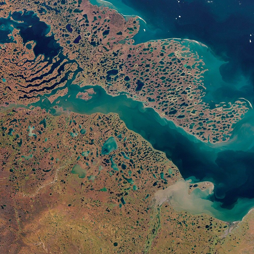
Reed-covered mounds exposed by declining water levels reveal an unexpected network of freshwater springs that feed directly into the lake basin.

A blanket of snow spanned Michigan and much of the Great Lakes region following a potent cold snap.
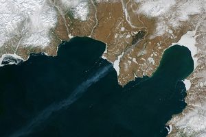
December and January brought a series of intense winter storms to the peninsula in far eastern Russia.

Tens of thousands of people fled to safety as blazes spread throughout the country’s Biobío and Ñuble regions.
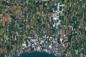
The expansion of greenhouses in southern Ontario is changing the appearance of the land surface—and the night sky.
After marching from Selma, Martin Luther King Jr. stood on the steps of the state capitol in Montgomery, Alabama, and called for nonviolence in the fight for equality and justice for all Americans.

A vibrant display of phytoplankton encircled the remote New Zealand islands.

A collection of fish-shaped clouds hovered above the glacial lake in Patagonia in December 2025.
An increasingly flammable landscape combined with more lightning strikes is leading to larger, more frequent, and more intense fires than the landscape is adapted for.

Satellite-based maps show northern wildland fires becoming more frequent and widespread as temperatures rise and lightning reaches higher latitudes.

The category 5 hurricane stirred up carbonate sediment near Jamaica in what scientists believe is the largest such event in the satellite record.

Blazes spread across Los Alerces National Park, home to some of the world's oldest trees.

Low clouds blanketed the delta while parallel cloud bands rolled over the Bay of Bengal during a January cold wave.
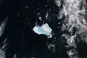
After a four-decade run, the massive, waterlogged berg is leaking meltwater and on the verge of disintegrating.

Vivid green blooms form, drift, and fade in Hartbeespoortdam reservoir over the course of a year.

(Grades 9-12+) This 5-minute-long video provides an introduction to electromagnetic spectrum.

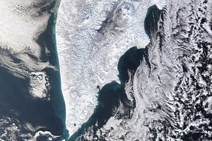
The Huíla plateau, bounded by dramatic cliffs and chasms, stands above the arid coastal plains in the country’s southwest.

The colorful formations found in this bowl-shaped escarpment in southwestern Utah are the centerpiece of Cedar Breaks National Monument.

Rounding out a remarkable year, the outback lake displayed distinct green and reddish water in its two main bays.
Get the Earth Observatory in your Inbox
Subscribe to our newsletters
We will never share your email address.