


browse image fororbit 14388 (210 KB JPEG)
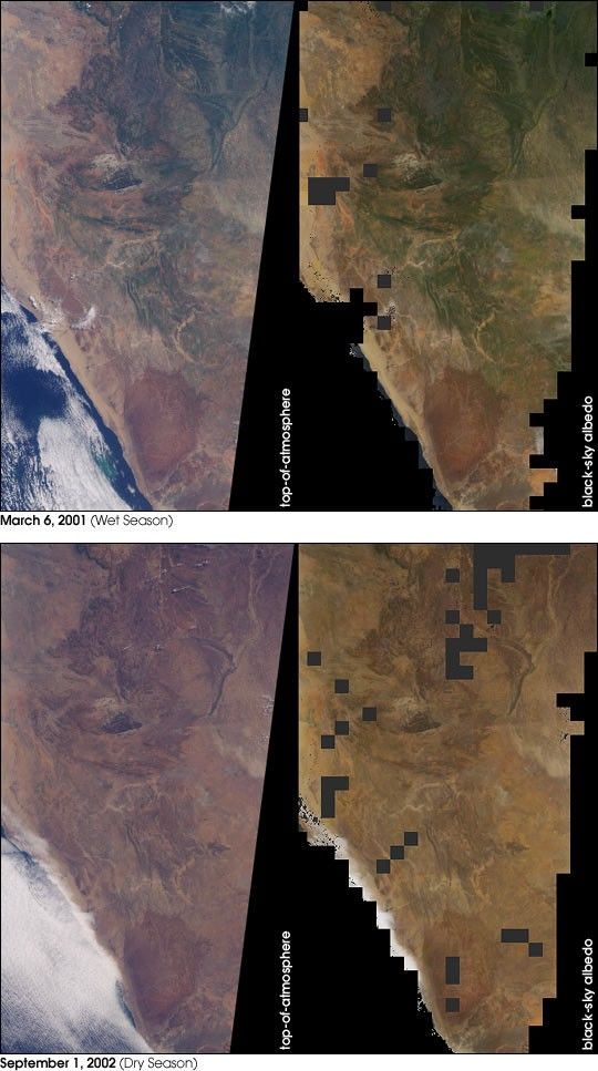
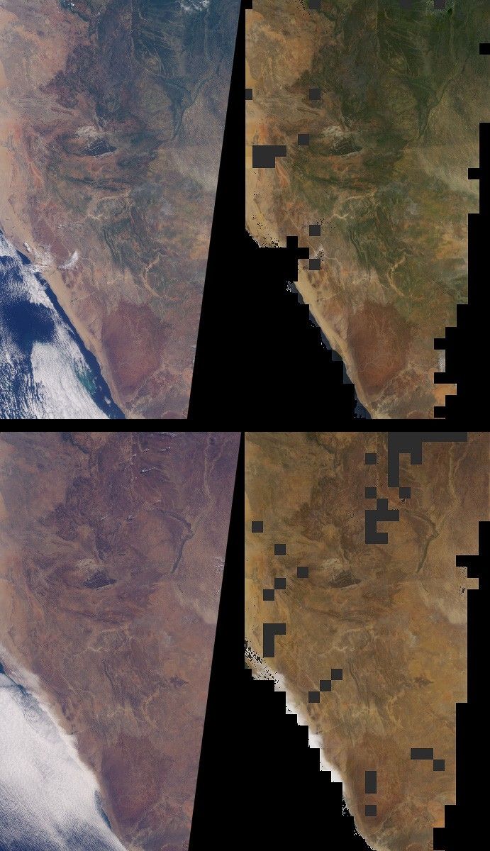
Brightness variations in the terrain along a portion of southwesternAfrica are displayed in these views from the Multi-angle ImagingSpectroRadiometer (MISR). The panels portray an area that includesNamibia’s Skeleton Coast and Etosha National Park as well as Angola’sCuando Cubango. The top panels were acquired on March 6, 2001, duringthe region’s wet season, and the bottom panels were acquired onSeptember 1, 2002, during the dry season. Corresponding changes in theabundance of vegetation are apparent. The images on the left are naturalcolor (red, green, blue) images from MISR’s vertical-viewing (nadir)camera. The images on the right represent one of MISR’s derived surfaceproducts.
The radiance (light intensity) in each pixel of the so-called#8220;top-of-atmosphere” images on the left includes light that is reflectedby the Earth’s surface in addition to light that is transmitted andreflected by the atmosphere. The amount of radiation reflected by thesurface into all upward directions, as opposed to any single direction,is important when studying Earth’s energy budget. A quantity called thesurface “directional hemispherical reflectance” (DHR), sometimes calledthe “black-sky albedo,” captures this information, and is depicted inthe images on the right. MISR’s multi-angle views lead to more accurateestimates of the amount of radiation reflected into all directions thancan be obtained as a result of looking at a single (e.g., verticallydownward) view angle. Furthermore, to generate this surface productaccurately, it is necessary to compensate for the effects of theintervening atmosphere, and MISR provides the ability to characterizeand account for scattering of light by airborne particulates(aerosols).
The DHR is called a hemispherical reflectance because it measures theamount of radiation reflected into all upward directions, and whichtherefore traverses an imaginary hemisphere situated above each surfacepoint. The “directional” part of the name describes the illuminationgeometry, and indicates that in the absence of an interveningatmosphere, light from the Sun illuminates the surface from a singledirection (that is, there is no diffuse skylight, hence the “black-sky”terminology). The DHR is retrieved over land surfaces in each of MISR’sfour wavelength bands, and the images on the right are red, green, bluespectral composites. Regions where DHR could not be derived, either dueto an inability to retrieve the necessary atmospheric characteristics ordue to the presence of clouds, are shown in dark gray.
The Multi-angle Imaging SpectroRadiometer observes the daylit Earthcontinuously and every 9 days views the entire globe between 82 degreesnorth and 82 degrees south latitude. The MISR Browse Image Viewer provides access tolow-resolution true-color versions of these images. These data products were generatedfrom a portion of the imagery acquired during Terra orbits 6466 and14388. The panels cover an area of about 380 kilometers x 760kilometers.
References & Resources
Image courtesy NASA/GSFC/LaRC/JPL, MISR Team Text by Clare Averill (Acro Service Corporation/Jet Propulsion Laboratory) and David J. Diner (Jet Propulsion Laboratory).


