February 27, 2017
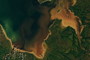
The Salinas and Pajaro rivers dumped sediment into Monterey Bay on February 27, 2017. The Advanced Land Imager (ALI) aboard NASA’s Earth Observing-1 (EO-1) satellite captured this natural-color image that day.
High water levels in several rivers in Monterey County prompted evacuations in late February, and high winds left thousands of people without electricity, according to local news reports. The surging rivers are the result of heavy rains across California this winter, including several atmospheric river events that caused inland flooding.
References & Resources
- NASA Earth Observatory (2017, January 12) Atmospheric River Soaks California.
- The Mercury News (2017, February 20) Atmospheric River Soaks California. Accessed March 3, 2017.
NASA Earth Observatory image by Jesse Allen, using EO-1 ALI data provided courtesy of the NASA EO-1 team. Caption by Pola Lem.