


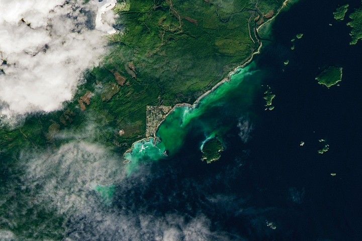
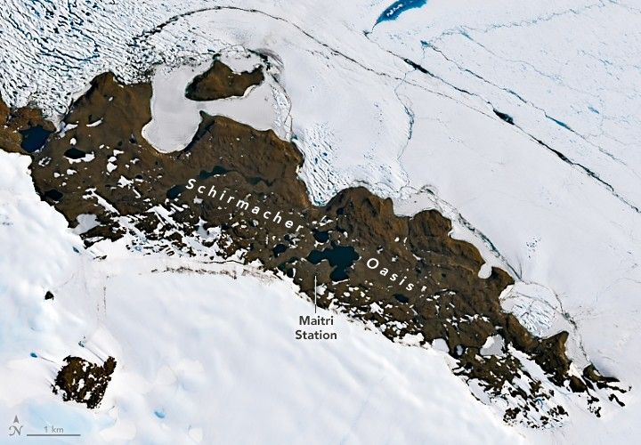
Summer is a busy season at Schirmacher Oasis, a rocky, ice-free plateau in Queen Maud Land, East Antarctica. Located near the grounding line of Nivlisen Ice Shelf and about 100 kilometers (60 miles) from the open waters of the Lazarev Sea, the "oasis" of land amid an otherwise continuous expanse of ice is home to dozens of small ice-covered freshwater lakes and two research stations.
It's the season when all-white snow petrels are sometimes spotted soaring over the oasis, and fuzzy south polar skua and Wilson's storm petrel chicks grow up in sheltered crevices on its cliffs and ridges. Under constant sunlight, the plateau's freshwater lakes come to life, supporting cyanobacterial growth and teeming with microscopic tardigrades, rotifers, and nematodes. At times, groups of Adélie penguins toddle through the oasis and attempt to breed.
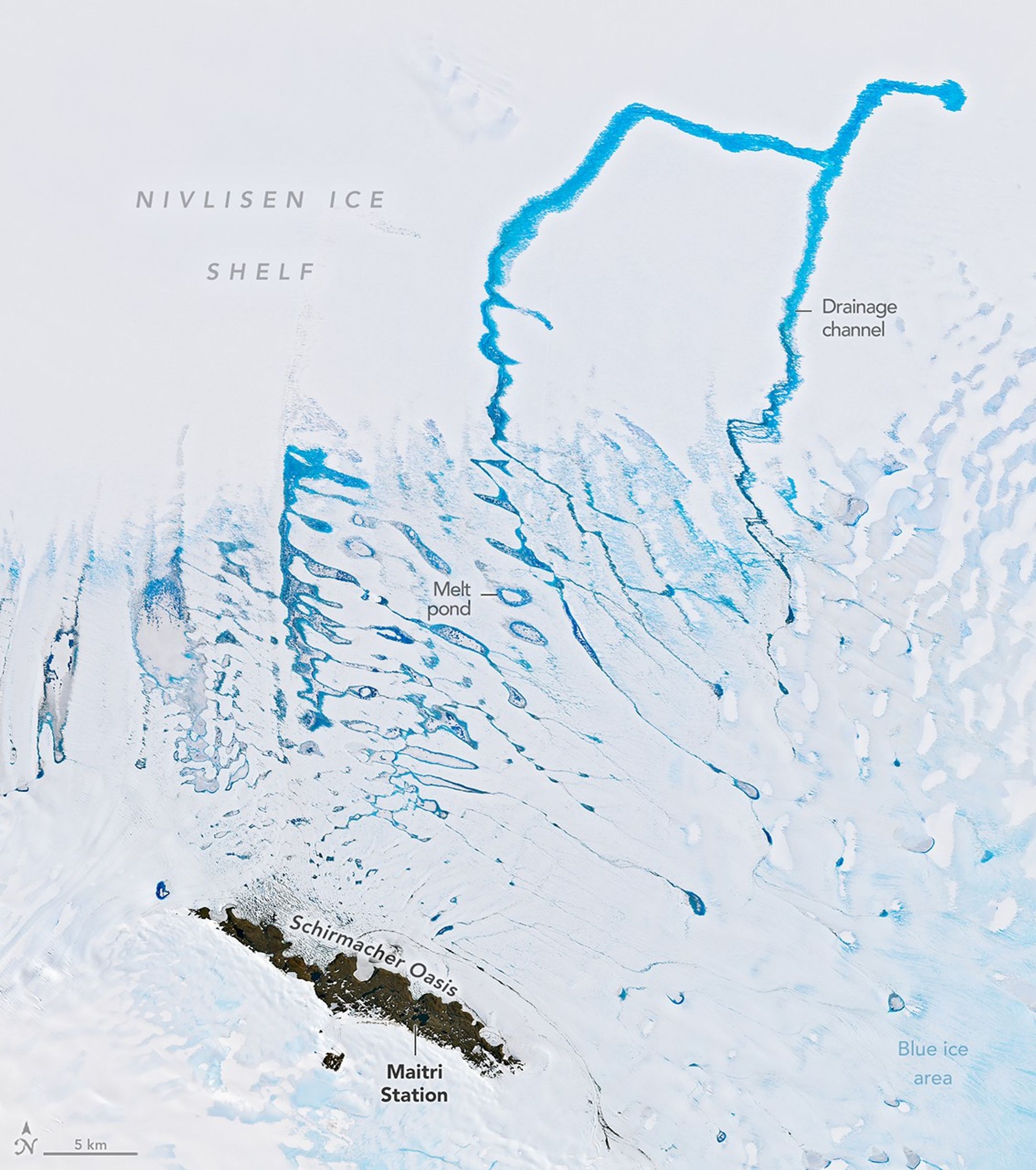
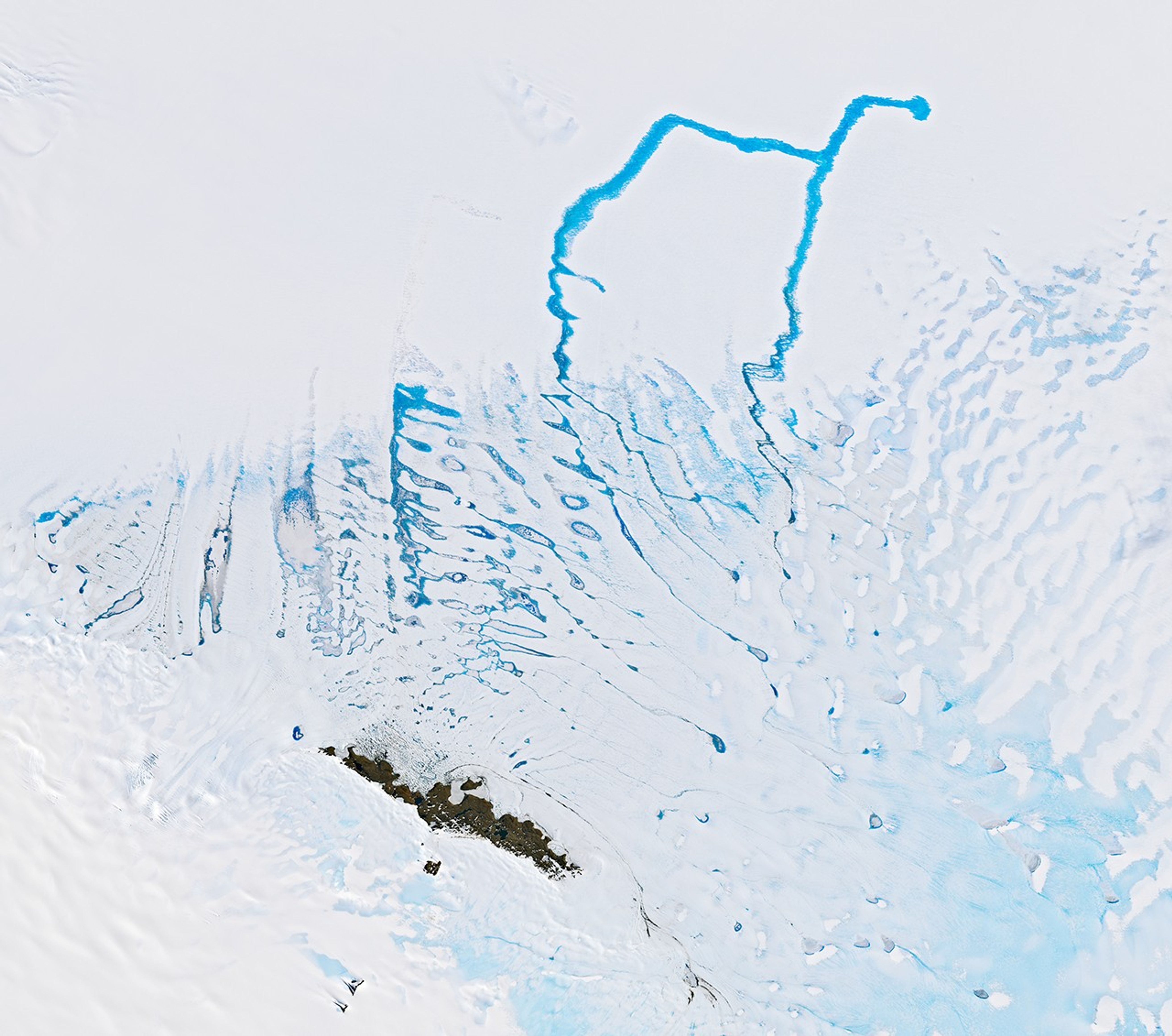
The summer months are also when temperatures creep just above freezing long enough for expansive networks of seasonal melt ponds and drainage channels on and within the surrounding ice to fill with bright blue meltwater that flows north onto and across the Nivlisen Ice Shelf. The satellite image above shows seasonal melt on January 6, 2026, during the peak of the 2026 melt season.
The Nivlisen Ice Shelf is a floating tongue that forms as glacial ice flows off Antarctica and into the waters of the Lazarev Sea. The many blue ice areas found around the oasis are snow-free areas where old, compressed glacial ice with few air bubbles has been exposed by powerful katabatic winds and sublimation. This dense ice absorbs red wavelengths of light and reflects blue wavelengths, making it appear blue. Blue ice areas are rare in Antarctica, covering about 1 percent of the continent's surface.
"The image captures the Nivlisen Ice Shelf during a phase of strong, system-wide hydrological connectivity," said Geetha Priya Murugesan, a remote sensing scientist with the Jyothy Institute of Technology in Bengaluru, India. Such features aren't always visible in optical satellite imagery, she added, noting that they are often frozen, buried under snow, or drained. "This image is notable because the 'cerulean veins' we see on the surface align with a deeper, persistent plumbing system that we monitor with radar."
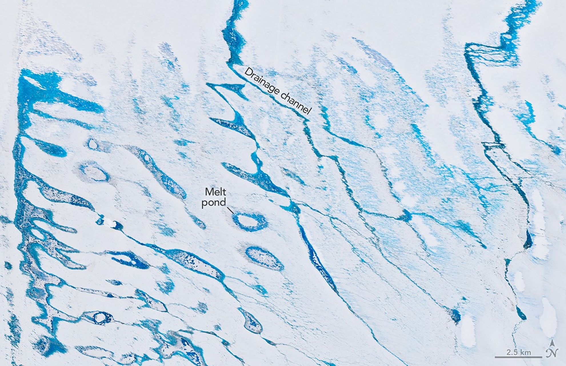
Murugesan and colleagues have analyzed decades of satellite data and conducted several years of field research in the area, including in 2026. Their work shows that since 2000, the surface melting caused by seasonal melt ponds and channels on the ice shelf has grown in depth, area, and volume. The depth and volume of melt features grew by a factor of 1.5, while their surface area increased by a factor of 1.2.
Murugesan thinks that the visibility of the drainage network in images like these hints at a deeper vulnerability of the ice shelf. The drainage channels trace preexisting structural weaknesses, including crevasses, that act as "hydraulic pathways” that concentrate meltwater in vulnerable zones near the grounding line, where it can weaken the ice shelf, Murugesan said.
The researchers have also linked peak melting periods like this one to atmospheric rivers and foehn winds that enhance surface melting and help route meltwater through the drainage networks. The dark color—low albedo—of the many blue ice areas surrounding the oasis contributes to drainage events by making ice surfaces less reflective, warmer, and thus more prone to summer melting, Murugesan added.
While Murugesan and colleagues are currently conducting a detailed analysis of the 2026 melt season to determine how it compares to past years, she said it appears to be a "strong melt event consistent with elevated melt conditions."
NASA Earth Observatory images by Michala Garrison, using Landsat data from the U.S. Geological Survey. Story by Adam Voiland.
References & Resources
- Chen, J., et al. (2026) Interannual and Seasonal Evolution of Supraglacial Channel Networks on Nivlisen Ice Shelf, East Antarctica. Egusphere, preprint.
- Chouksey, A., et al. (2021) Mapping and identification of ice-sheet and glacier features using optical and SAR data in parts of central Dronning Maud Land (cDML), East Antarctica. Polar Science, 30, 100740.
- EGU Blogs (2024, June 21) Blue ice in Antarctica: small extent, big science. Accessed March 26, 2026.
- Murugesan, G.P., et al. (2025) Surface Melt Assessment of Nivlisen Ice Shelf, East Antarctica via SAR Satellite Data Analysis During Austral Summer 2022-2023. In: Shukla, P.K., et al. Computer Vision and Robotics. CVR 2024. Algorithms for Intelligent Systems. (Springer, Singapore.)
- Murugesan, G.P., et al. (2024) Monitoring of Melt Ponds and Supra-Glacial Lakes over Nivlisen Ice Shelf, East Antarctica, Using Satellite-Based Multispectral Data. Civil Engineering Innovations for Sustainable Communities with Net Zero Targets.
- Murugesan, G.P., et al. (2023) Decoding the Dynamics of Climate Change Impact: Temporal Patterns of Surface Warming and Melting on the Nivlisen Ice Shelf, Dronning Maud Land, East Antarctica. Remote Sensing, 15(24), 5676.
- Pande, A., et al. (2020) Past records and current distribution of seabirds at Larsemann Hills and Schirmacher Oasis, east Antarctica. Polar Record, 56, e40
- Ryan, P.G. (2024) Notes on the birds of Schirmacher Oasis. Marine Ornithology, 52(2).
- Tollenaar, V., et al. (2024) Where the White Continent Is Blue: Deep Learning Locates Bare Ice in Antarctica. Geophysical Research Letters, 51(3), e2023GL106285.


