


April 2, 2016
Sierra Nevada Snowpack is Better, but Not Normal
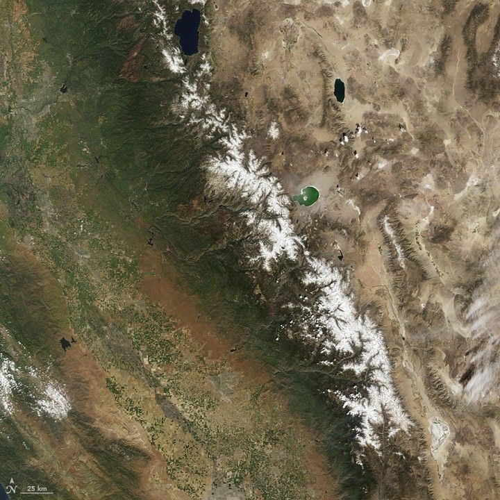
One year after snow surveyors stood on a dusty mountainside in California and reported that snow-water content was just 5 percent of normal, the situation in the Sierra Nevada range is much improved. But it is still not normal.
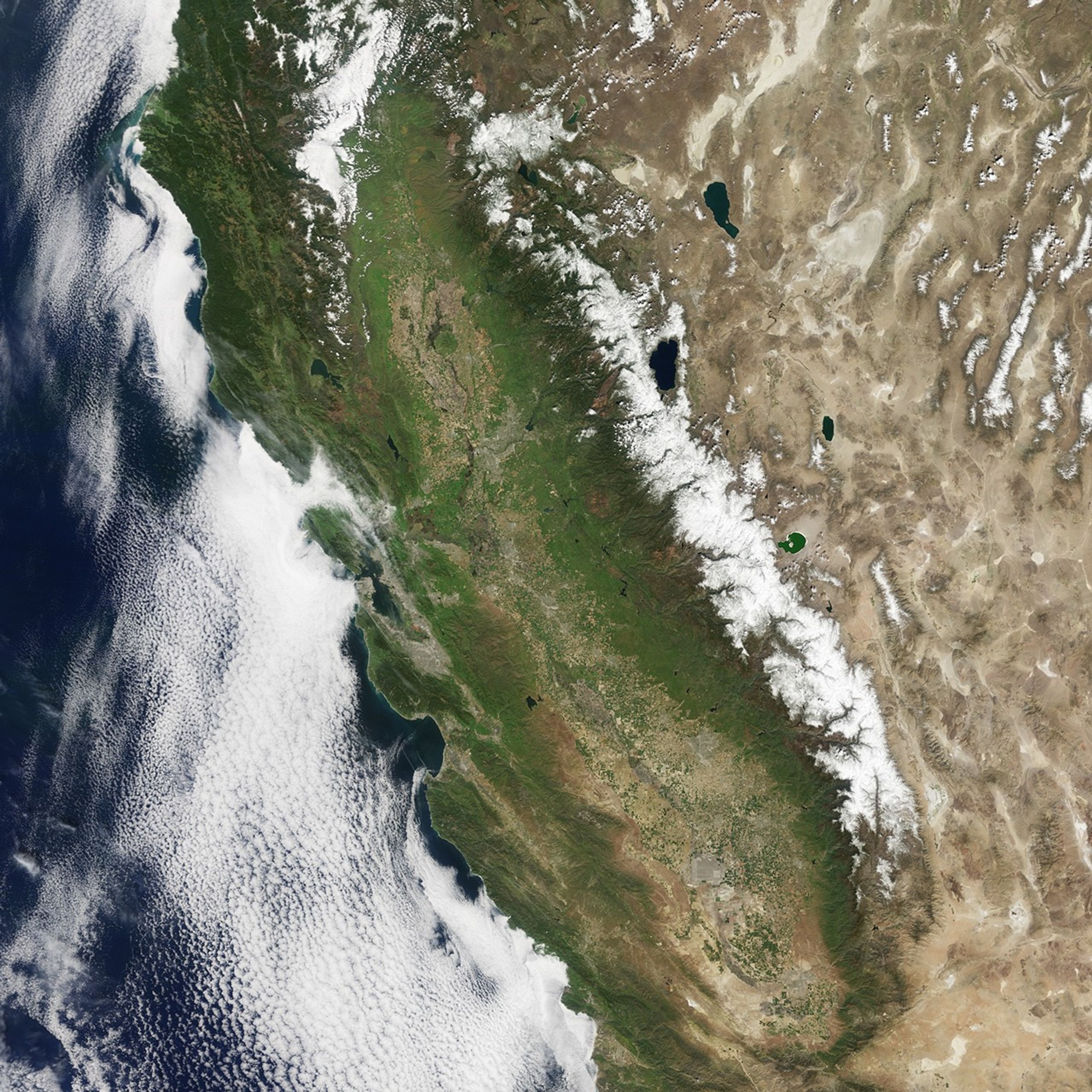
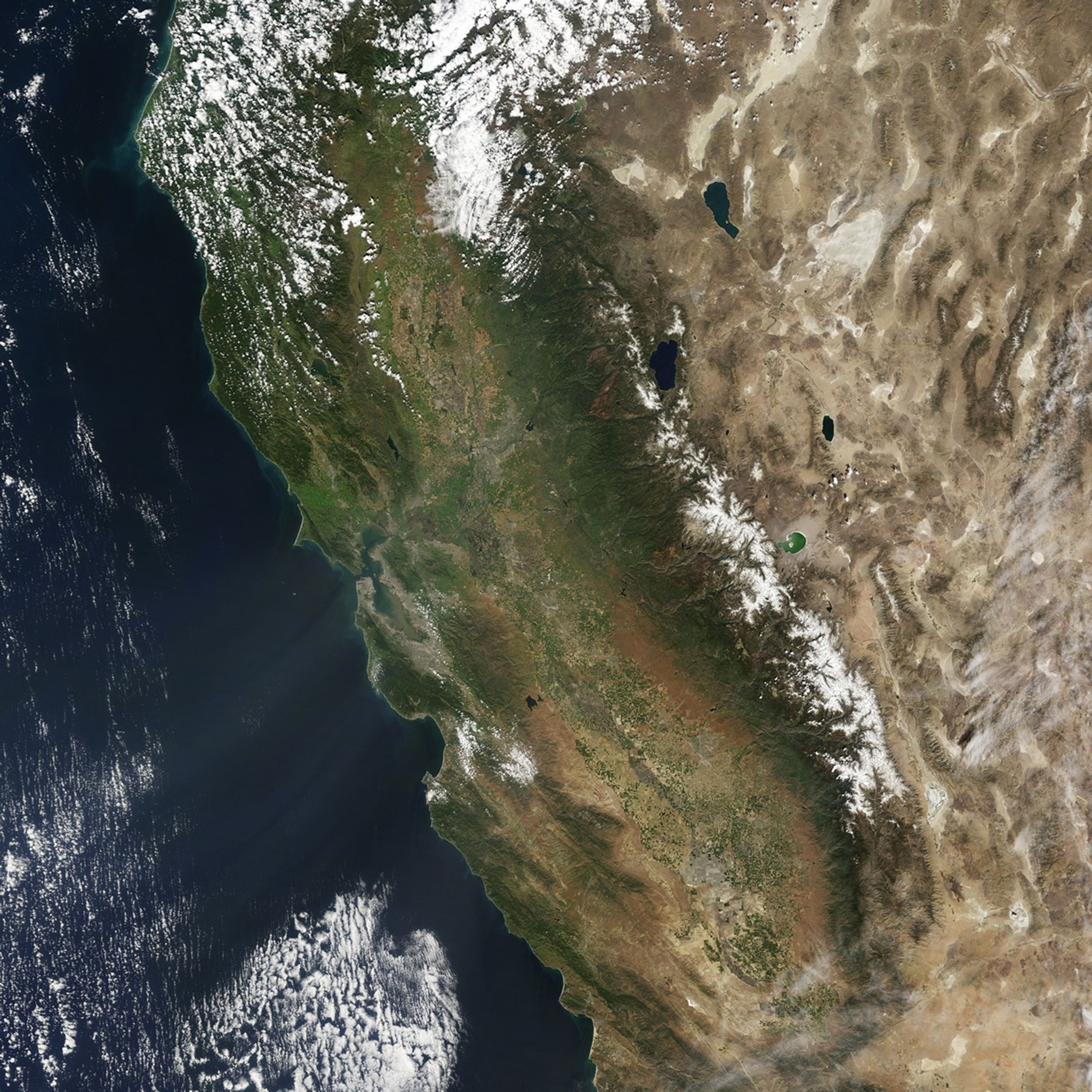
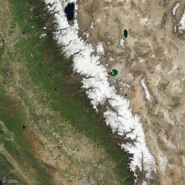
The California Department of Water Resources (DWR) reported on March 30, 2016, that snow cover in the mountains was 87 percent of the long-term average. Snow that falls in the mountains is often powdery and dry at first, but as the winter progresses and the snow compacts, the water becomes concentrated. The rule of thumb is that 30 inches (76 centimeters) of snow in the Sierra Nevada range is equal to roughly 12 inches (30 centimeters) of fresh water once it melts.
As of March 30, the statewide average snow-water equivalent (SWE) was 24.4 inches. There were some regional differences, with 28.1 inches of SWE (97 percent) in the northern Sierra Nevada; 25.2 inches (88 percent) in the central region; and 19.3 inches (72 percent) in the southern region.
The Moderate Resolution Imaging Spectroradiometer (MODIS) on NASA’s Aqua satellite captured these natural-color images of the snow cover in the Sierra Nevada in California and Nevada. The top image was acquired on April 2, 2016; the second image was acquired a year earlier on March 31, 2015. In addition to the changing snow cover, note the change in color around the Central Valley of California. Turn on the image comparison tool for a better look.
In California, mountain snow cover provides about 30 percent of the yearly fresh water supply. Snow that falls on the mountains in winter melts and runs down into the valleys each summer and fall, providing water when rainfall is sparse. That melting has already begun, as temperatures are rising with the increasing spring sunlight. As of April 13, the average snow-water equivalent for the state was 19 inches, or 71 percent of normal.
“While for many parts of the state there will be both significant gains in both reservoir storage and stream flow, the effects of previous dry years will remain for now,” said Frank Gehrke, chief of the California Cooperative Snow Surveys in a March 30 press release. According to the U.S. Drought Monitor, nearly 90 percent of California was still in some level of drought as of April 5, 2016.
The state’s reservoirs also have been topped off by significant rainfall this winter. But neither the increased mountain snow nor rising reservoirs can offset all of the groundwater depletion in recent years.
You can observe a decade of snow-cover changes in California by visiting World of Change: Snowpack in the Sierra Nevada.
References & Resources
- California Department of Water Resources (2016, March 30) Sierra Nevada Snowpack Grew During First Half of March, But Dry Spell Leaves Water Content Still Below Average. Accessed April 13, 2016.
- NASA Earth Observatory (2016) Natural Hazards: Drought in the Western United States.
- NASA Earth Observatory (2016) World of Change: Snowpack in the Sierra Nevada.
- The New York Times (2016, April 11) Sierra Nevada Snow Won’t End California’s Thirst. Accessed April 13, 2016.
- NASA Earth Observatory (2014, April 3) Finding Water in Snow.
- NASA Jet Propulsion Laboratory (2015) NASA Airborne Snow Observatory. Accessed April 13, 2016.
NASA Earth Observatory images by Jesse Allen, using data from the Level 1 and Atmospheres Active Distribution System (LAADS). Caption by Mike Carlowicz.