


browse image of orbit 16602 (340 KB JPEG)
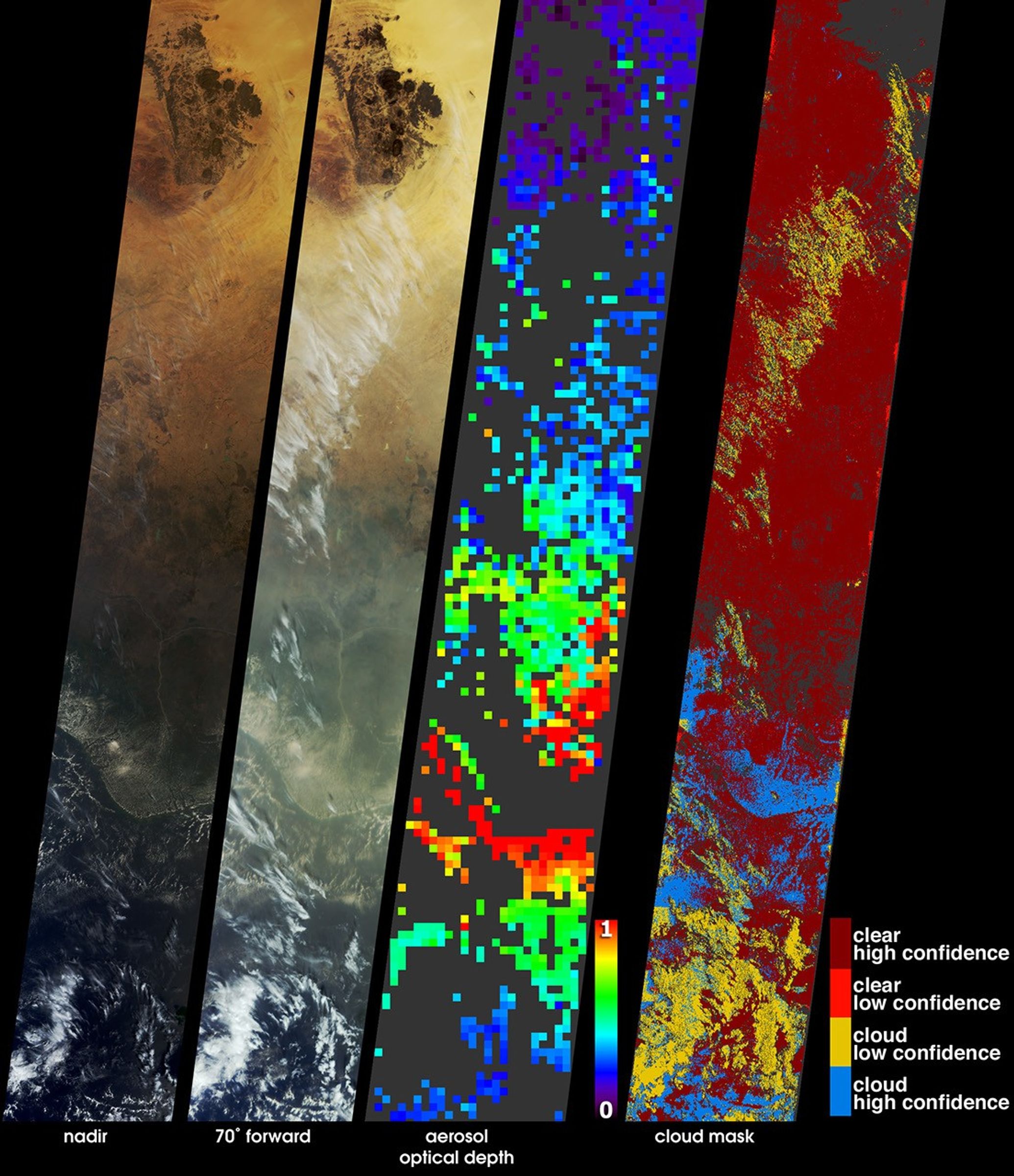
These images and data products from the Multi-angle ImagingSpectroRadiometer (MISR) document extensive smoke from fires burningthroughout Nigeria and north central Africa on January 31, 2003. At leftare natural-color views acquired by MISR's vertical-viewing (nadir) andmost oblique forward viewing cameras. The images extend from arid Nigerin the north (including the dark-colored A‹r Mountains), throughforested Nigeria, and beyond the Niger Delta to the Gulf of Guinea andthe open ocean. Smoke present in the lower portion of the images, and aseries of thin, high clouds, are more apparent at the oblique viewangle. Although numerous small smoke plumes emanate from fires buringwithin the image area, some of the smoke can also be attributed to firesthat were burning across the north central African Sahel and savannaregions at this time and during the previous two weeks.
A map of aerosol optical depth, which is a measure of atmosphericparticle abundance, is shown at center-right. MISR utilizes the changesin the atmosphere's ability to transmit light and the variation in scenebrightness at different view angles to retrieve aerosol optical depthand deduce some of the properties of the particles. A thick pall ofsmoke is present over Nigeria and the Gulf of Guinea, indicated bygreen, yellow and red pixels over these regions. Clear skies areindicated by the blue and purple pixels over the desert regions andocean. Places where clouds or other factors precluded an aerosolretrieval are shown in dark gray.
The position of clouds appears to move with view angle relative tothe ground due to geometric parallax. MISR utilizes the parallax effectto generate its stereo height fields. The right-hand panel is astereoscopically derived cloud mask (SDCM), which classifies regions asclear or cloudy based upon their heights above the surface and is one ofseveral cloud masks produced by MISR. The high and low confidencedesignations are related to how well the stereo height retrievalalgorithms were able to determine the absolute height of the clouds. Thepall of smoke, unlike the clouds and underlying surface, does notcontain an organized spatial texture, and the stereo retrievals classifythe smoke-filled regions as clear despite the large abundance ofairborne particles.
The Multi-angle Imaging SpectroRadiometer observes the daylit Earthcontinuously and every 9 days views the entire globe between 82 degreesnorth and 82 degrees south latitude. The MISR Browse Image Viewer provides access tolow-resolution true-color versions of these images. These data products were generatedfrom a portion of the imagery acquired during Terra orbit 16602. Thepanels cover an area of about 380 kilometers x 2520 kilometers.
References & Resources
Image courtesy NASA/GSFC/LaRC/JPL, MISR Team. Text by Clare Averill (Acro Service Corporation/JPL).


