


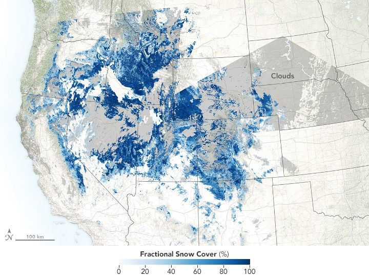
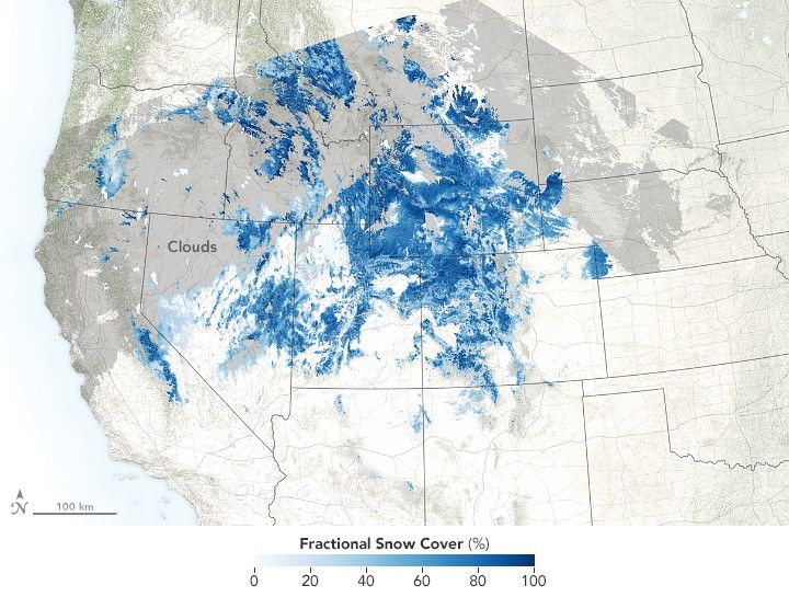


January 25, 2016-January 29, 2018
A snow drought doesn’t just make for a bad ski season. If a snow deficit continues into late winter and spring, it can spell trouble for water managers and communities that depend on melt water to fill reservoirs. In parts of the Rocky Mountains, the early and mid-winter of 2017-2018 failed to deliver much snow.
These maps show late January snow cover in a typical year (2016) and in the middle of the recent snow-drought (2018). The maps were made from observations collected by the Moderate Resolution Imaging Spectroradiometer (MODIS) on NASA’s Terra satellite. Dark blue areas have the most snow cover (100 percent); lighter blue areas have progressively less snow cover. Gray areas show where satellites could not collect data due to cloud cover. Turn on the image comparison tool to see the difference.
As of February 1, 2018, snowpack in the Southern Rockies was below normal, according to the National Oceanic and Atmospheric Adminstration. The Southern Rockies spread across southern Wyoming, Utah, New Mexico, and Colorado—the location of the highest peaks in the range.
News reports from Colorado noted that the snowpack was “on track to be one of the lowest in recent history.” The snowpack across the entire state was 60 percent of normal. Such shortages are a concern, given that people in Colorado and states to the west use the snowmelt from this part of the Rockies for drinking and farming.
The Northern Rockies fared better, with above-average snowpack in parts of Wyoming and Montana, according to the NOAA report. The snowpack in the Central Rockies hovered near or just-below normal.
Experts say there is still time for improvement. Snowpack in the Southern Rockies tends to come from a few big storms, in contrast to more frequent snowfalls to the north. Experts will know more in springtime, when NASA’s Airborne Snow Observatory (ASO) resumes annual flights that use lidar to measure the snow. Data from ASO—characterizing everything from snow depth, snow water equivalent, and albedo—are an important guidance tool for water managers. The ASO team plans to survey California in March, and then head east for a survey over Colorado.
References & Resources
- The Denver Post (2018, February 7) Despite burst of January snow, Colorado mountain snowpack stays grim—with record low levels at some sites. Accessed February 22, 2018.
- The Durango Herald (2018, January 20) Can the low snowpack in Southwest Colorado rebound? Accessed February 22, 2018.
- NOAA National Centers for Environmental Information (2018, January) National Snow & Ice – January 2018. Accessed February 22, 2018.
- Outside (2018, January 5) This Is Literally the West’s Worst Winter in 60 Years. Accessed February 22, 2018.
NASA Earth Observatory images by Joshua Stevens, using MODIS snow cover data from the Jet Propulsion Laboratory. Story by Kathryn Hansen.


