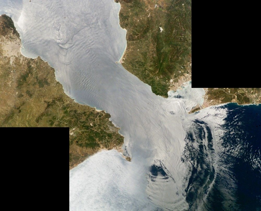
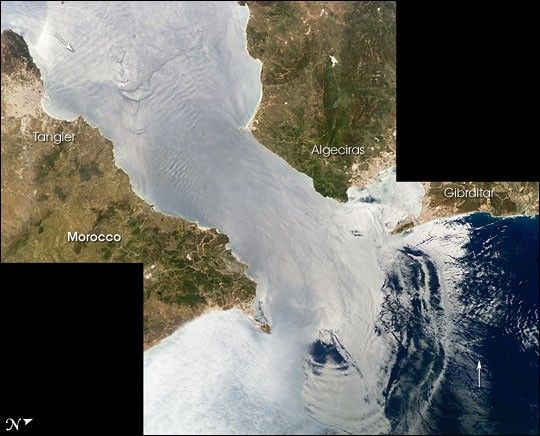
Surf’s up! This image is a mosaic of two photographs taken by astronauts aboard the International Space Station viewing large internal waves in the Strait of Gibraltar. These subsurface internal waves occur at depths of about 100 m, but appear in the sunglint as giant swells flowing eastward into the Mediterranean Sea.
The narrow Strait of Gibraltar is the gatekeeper for water exchange between the Atlantic Ocean and Mediterranean Sea. A top layer of warm, relatively fresh water from the Atlantic Ocean flows eastward into the Mediterranean Sea. In return, a lower, colder, saltier layer of water flows westward into the North Atlantic ocean. A density boundary separates the layers at about 100 m depth.
Like traffic merging on a highway, the water flow is constricted in both directions because it must pass over a shallow submarine barrier, the Camarinal Sill. When large tidal flows enter the Strait, internal waves (waves at the density boundary layer) are set off at the Camarinal Sill as the high tide relaxes. The waves—sometimes with heights up to 100 m—travel eastward. Even though the waves occur at great depth and the height of the waves at the surface is almost nothing, they can be traced in the sunglint because they concentrate the biological films on the water surface, creating slight differences in roughness.
In this image, the tidal bore creates internal waves (top arrow) that propagate eastward and expand outward into the Mediterranean in a big arc (near bottom). Other features can be traced in the sun’s reflections. Linear and V-shaped patterns (bottom arrow) are wakes of ships, providing evidence for the heavy ship traffic through the narrow waters between Spain and Morocco.
Water features in the sunglint pattern appear to the astronaut to be extremely transient, visible only briefly (a few seconds) as the spacecraft passes rapidly overhead. Photographs from space of the ocean sunglint pattern are a tool for studying physical oceanographic and atmospheric processes and other phenomena that affect surface roughness.
References & Resources
- References:
- Internal Waves, Strait of Gibraltar
- Christopher O. Tiemann, Peter F. Worcester, Bruce D. Cornuelle, Effects of Internal Waves and Bores on Acoustic Transmissions in the Strait of Gibraltar, Conference Proceedings from Internal Solitary Wave Workshop, Victoria, B.C., Canada, October 1998. Woods Hole Oceanographic Institution Technical Report WHOI-99-07
- Oceanography from the Space Shuttle, Solitons, Gibraltar
Astronaut photographs ISS009-E-9952 and ISS009-E-9954 were taken June 3, 2004 with a Kodak DCS760 digital camera equipped with a 180 mm lens, and are provided by the Earth Observations Laboratory, Johnson Space Center. The International Space Station Program supports the laboratory to help astronauts take pictures of Earth that will be of the greatest value to scientists and the public, and to make those images freely available on the Internet. Additional images taken by astronauts and cosmonauts can be viewed at the NASA/JSC Gateway to Astronaut Photography of Earth.