


February 23-April 29, 2020
Spring Greening in the Taklamakan Desert
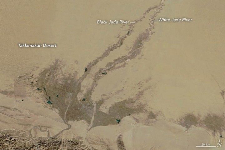
In the local Ugyur language, China’s Taklamakan Desert roughly translates to: “You go in, but you won’t come out.” It is the country’s hottest, driest, and largest desert—about the same size as Germany. Roughly 85 percent of the Taklamakan consists of shifting sand dunes, some of which soar up to 200 to 300 meters (650 to 900 feet) in height. The world’s second largest moving-sand desert is also prone to massive dust storms.
But even in this dry, dangerous desert nicknamed the “Sea of Death,” plant life sprouts in the springtime. The images above show a portion of the Taklamakan Desert by the oasis town of Hotan on February 23 and April 29, 2020, as vegetation sprouted on the landscape. The images were acquired by the Moderate Resolution Imaging Spectroradiometer (MODIS) on NASA’s Terra satellite.
Since portions of the desert receive less than 10 millimeters (0.4 inches) of rain per year, much of the water for the vegetation is runoff from surrounding mountain ranges. For instance, spring and summer snowmelt from the Kunlun Mountains (seen at the bottom of the images) helps fill the White Jade and Black Jade Rivers, which in turn provide water for vegetation and the town of Hotan. The two rivers flow north and merge into the Hotan River, which continues across the Tarim Basin.
In recent years, workers have been planting more vegetation around the Taklamakan Desert, specifically around the Tarim Desert Highway. The 550-kilometer (340-mile) stretch of road is the world’s longest desert highway. To protect the highway from sand storms, local governments planted a 430-kilometer (270-mile) long belt of vegetation along the road over the past decade. Workers have introduced additional greening projects in other locations such as the Gobi Desert.
References & Resources
- JAXA Earth Observation Research Center (2004, July 21) Mysterious River Advances through Desert. Accessed May 4, 2020.
- NASA Earth Observatory (2016, May 3) The Taklimakan Desert: A Factory for Dust Storms.
- NASA MODIS (2020, April 29) Greening in the Taklamakan Desert. Accessed May 4, 2020.
- New China TV (2013, September 17) Greening the âDesert of death.â Accessed May 4, 2020.
- Pulitzer Center (2009, May 12) China: The Sea of Death. Accessed May 4, 2020.
- Wired (2017, October 10) The Lush Billion-Tree Spectacle of Chinaâs Great Green Wall. Accessed May 4, 2020.
- Xinhua (2017, October 27) Oil workers make âheartâ of Chinaâs largest desert green and vibrant. Accessed May 4, 2020.
NASA Earth Observatory images by Lauren Dauphin, using MODIS data from NASA EOSDIS/LANCE and GIBS/Worldview. Story by Kasha Patel.


