


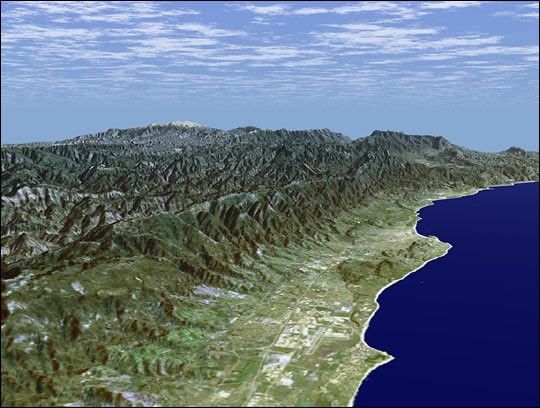
Santa Barbara, California, is often called "America's Riviera." Itenjoys a Mediterranean climate, a mountain backdrop, and a long andvaried coastline. This perspective view of the Santa Barbara region wasgenerated using data from the Shuttle Radar Topography Mission (SRTM)and an enhanced Landsat satellite image. The view is toward thesoutheast, from the Goleta Valley in the foreground to a snow-cappedMount Abel (elevation 2526 m or 8286 feet) along the skyline. The coasthere generally faces south. Consequently, Fall and Winter sunrises occurover the ocean, which is unusual for the U.S. west coast. The SantaBarbara "back country" is very rugged and largely remains as undevelopedwilderness and an important watershed for local communities. Landsat hasbeen providing visible and infrared views of the Earth since 1972. SRTMelevation data match the 30-meter resolution of most Landsat images andwill substantially help in analyses of the large and growing Landsatimage archive. For visualization purposes, topographic heights displayedin this image are exaggerated two times. Colors approximate naturalcolors.
The elevation data used in this image was acquired by SRTM aboard theSpace Shuttle Endeavour, launched on February 11, 2000. SRTM used thesame radar instrument that comprised the Spaceborne ImagingRadar-C/X-Band Synthetic Aperture Radar (SIR-C/X-SAR) that flew twice onEndeavour in 1994. SRTM was designed to collect three-dimensionalmeasurements of Earth's land surface.
Location (Isla Vista): 34.41 deg. North lat., 119.85 deg. West lon.
View: East
Scale: Scale Varies in this Perspective
Date Acquired: February 16, 2000 SRTM, December 14, 1984 Landsat
References & Resources
Image courtesy NASA/JPL/NIMA/USGS, SRTM Science Team