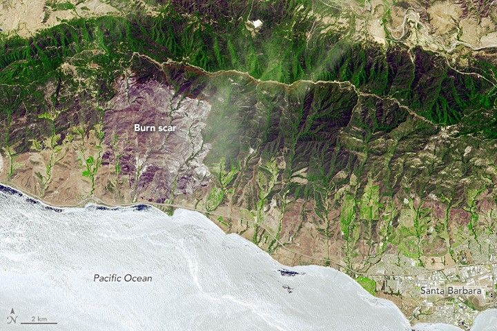
In June 2016, more than 1,000 firefighters battled a wildfire burning west of Santa Barbara, California. While they managed to contain the fire before it caused damage to homes or infrastructure, the Sherpa fire still charred 7,474 acres (3,024 hectares) of the landscape as of June 29.
The Advanced Spaceborne Thermal Emission and Reflection Radiometer (ASTER) on the Terra satellite acquired an image of the burn scar (above) on June 19, 2016. Vegetation-covered land is green in this false-color image, which includes both visible and infrared light. Patches of unburned forest are gray. Buildings, roads, and other developed areas appear white. The photograph below, taken from a firefighting airplane, shows smoke rising from the fire on June 15, 2016.

NASA’s DC-8 and ER-2 airplanes collected imagery and other scientific data of the fire as well. As reported by the University of California, Santa Barbara, the planes happened to be flying in the area as part of NASA’s Student Airborne Research Program (SARP). The aircraft were collecting measurements of atmospheric trace gases, aerosols, and solar radiation as they passed over the fire on June 17, 2016.
The video below was shot from the DC-8 as the aircraft approached a smoke plume from the fire. Notice the turbulence, likely associated with the heat from the fire, that the plane faced as it approached the smoke.
The SARP students described their bumpy flight in a blog post: “Going into the flights, we were both nervous and excited, as we were thoroughly warned that flying would consist of many spirals and “missed approaches” at area airports in order to collect data closer to the ground. A missed approach means approaching the runway like you are going to land, but then pulling back up. These maneuvers would also involve a lot of turbulence, and the high temperatures meant the plane would be uncomfortably warm—all factors that contribute to airsickness. The maneuvers and low flying made seven people queasy.”
References & Resources
- InciWeb (2016, June 23) Sherpa Fire. Accessed June 29, 2016.
- Santa Barbara Independent (2016, June 23) Season Opener: A Sherpa Fire Retrospective. Accessed June 29, 2016.
- NASA Jet Propulsion Laboratory (2016, June 22) Major Wildfire Near Santa Barbara seen by NASA Spacecraft.
- The UC Santa Barbara Current (2016, June 23) Smokin’ Hot. Accessed June 29, 2016.
NASA Earth Observatory image by Jesse Allen, using data from NASA/GSFC/METI/ERSDAC/JAROS, and U.S./Japan ASTER Science Team. Photograph by Mark Nunez, Air Attack 07. Caption by Adam Voiland.