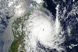
Typhoon Choi-wan had clearly degraded significantly by the time the Moderate Resolution Imaging Spectroradiometer (MODIS) on NASA’s Terra satellite captured this image on September 18, 2009. Though the storm maintains its tightly wound symmetric shape, the striking clear eye is gone. The storm has a cloudy eye in this image.
At the time the image was taken, 1:15 UTC or 10:15 a.m. in Japan immediately north of the storm, Choi-wan was a Category 3 typhoon. It was no longer a super typhoon, a name reserved for strong Category 4 and 5 storms. Choi-wan had winds of about 200 kilometers per hour (125 miles per hour or 110 knots), said the Joint Typhoon Warning Center. The storm was forecast to continue to weaken as it moved northeast.
The high-resolution image provided above is at MODIS’ full spatial resolution (level of detail) of 250 meters per pixel. The MODIS Rapid Response System provides this image at additional resolutions.
References & Resources
- Joint Typhoon Warning Center. (2009, September 18). Super Typhoon 15W (Choi-wan) Warning NR 026. Accessed September 18, 2009.
- Unisys Weather. (2009, September 18). Super Typhoon-5 Choi-wan. Accessed September 18, 2009.
NASA image by Jeff Schmaltz, MODIS Rapid Response Team, Goddard Space Flight Center.

