


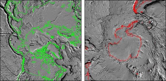
These tectonic relief maps of the north (left, view large [540k]) and south (right, view large [411k]) poles are the result of new satellite-based technologies which are being used to analyze tectonic activity in the Earth's crust. These maps, known as Digital Tectonic Activity Maps (DTAMs), synoptically depict the architecture of the Earth's crust including current and past tectonic activity. This is significant because it permits researchers to view broad zones of activity over the entire surface of the Earth, rather than focusing on single boundary features. By looking at these "big pictures," scientists can possibly identify regions of activity which were not previously recognized or mapped using traditional methods.
For more information, see:
DTAM web site
Putting Earthquakes in Their Place
References & Resources
Images courtesy Brian Montgomery, NASA GSFC; data by Paul Lowman and Jacob Yates, NASA GSFC
None


