


September 1-30, 2011
Thick Vegetation Fuels Australia Fires
Australia may be in for an intense fire season this spring and summer as the warm temperatures settle in. In late 2010 and early 2011, La Niña dumped flooding rains over the southern continent. The moist soil allowed thick grass to grow; now that the grass is drying out, it is fuel for fires. In Northern Australia, more than 150,000 square kilometers (58,000 square miles) have already burned.
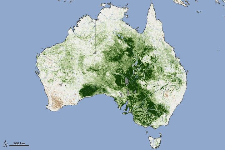
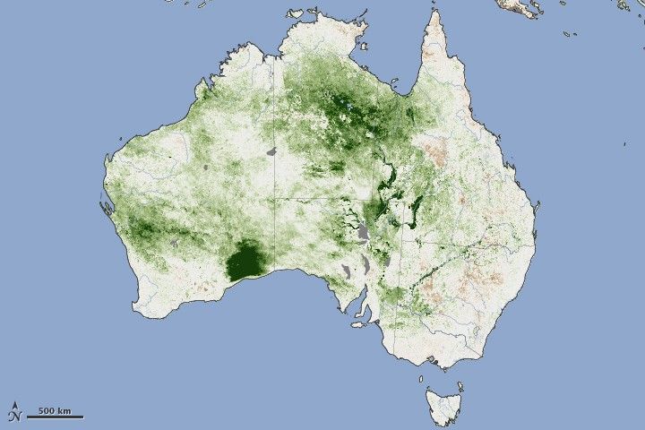
These vegetation maps show the build-up of grasses and other plants during the autumn (April) and the return to more normal conditions in the spring (September). The images were made with data from the Advanced Very High Resolution Radiometer on the NOAA-18 POES satellite and show plant growth in April and September as compared to the average, long-term growth for each month.
The measurement is an indication of how dense and leafy plants are and how much photosynthesis is going on. In April, Australia was covered with much denser growth than normal as thick grasses grew, especially in the interior of the country. Growth was still high in September, but conditions were closer to average in many areas.
What happened to all of the plants during the winter? They are still there, but the satellite now sees fewer green, photosynthesizing leaves. And all that dead or dry plant matter could fuel fires. In fact, emergency authorities in Australia are warning residents that the risk of grassland fires is very high this year. Fuel loads may reach their highest levels in 30 years, said news reports. Though not as hot or intense as forest fires, grass fires spread very quickly and can be erratic, making them extremely dangerous.
References & Resources
- Johnston, M. (2011, October 5). Torrid bushfire season tipped. Herald Sun. Accessed October 4, 2011.
- Nell, M. (2011, September 29). Drought, rain and now grass fire risk. Sydney Morning Herald. Accessed October 4, 2011.
NASA Earth Observatory image created by Jesse Allen, using data provided by the United State Department of Agriculture Foreign Agriculture Service and processed by Jennifer Small and Assaf Anyamba, NASA GIMMS Group at Goddard Space Flight Center and the Foreign Agriculture Service (FAS) Global Agricultural Monitoring Project (GLAM) Project.


