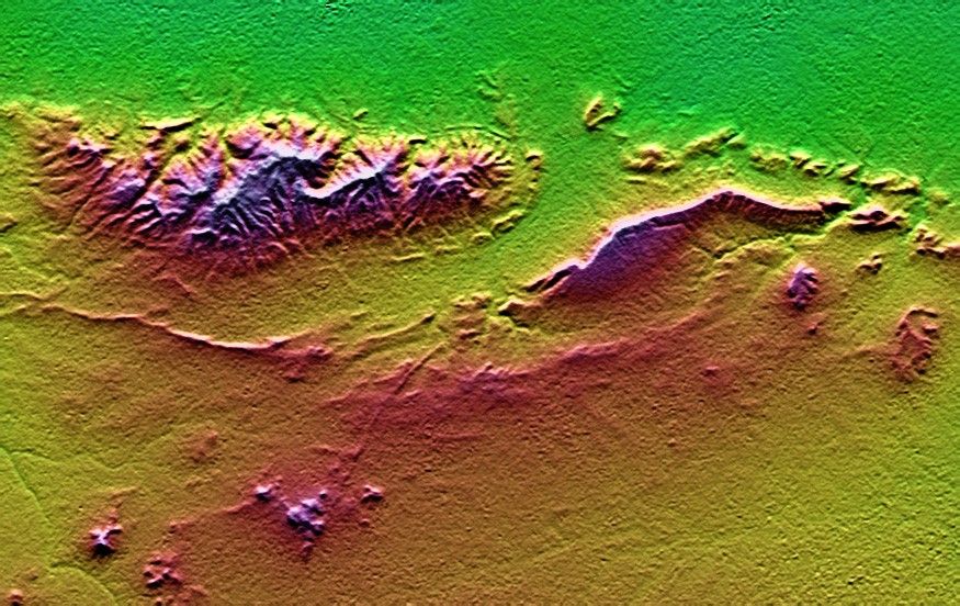


On January 26, 2001, the Kachchh region in western Indiasuffered the most deadly earthquake in India’s history. This shaded topographyview of landforms northeast of the city of Bhuj depicts geologic structuresthat are of interest in the study the tectonic processes that may have led tothat earthquake. However, preliminary field studies indicate that thesestructures are composed of Mesozoic rocks that are overlain by younger rocksshowing little deformation. Thus these structures may be old, not activelygrowing, and not directly related to the recent earthquake.
The Haro Hills are on the left and the Kas Hills are on the right. The HaroHills are an “anticline,” which is an upwardly convex elongated fold of layeredrocks. In this view, the anticline is distinctly ringed by an erosion resistantlayer of sandstone. The east-west orientation of the anticline may relate tothe crustal compression that has occurred during India’s northward movementtoward, and collision with, Asia. In contrast, the largest of the Kas Hillsappears to be a tilted (to the south) and faulted (on the north) block oflayered rocks. Also seen here, the linear feature trending toward the southwestfrom the image center is an erosion-resistant “dike,” which is an igneousintrusion into older “host” rocks along a fault plane or other crack. Thesefeatures are simple examples of how shaded topography can provide a directinput to geologic studies.
In this image, colors show the elevation as measured by the Shuttle RadarTopography Mission (SRTM). Colors range from green at the lowest elevations,through yellow and red, to purple at the highest elevations. Elevations hererange from near sea level to about 300 meters (about 1000 feet). Shading hasbeen added, with illumination from the north (image top).
Elevation data used in this image was acquired by the Shuttle Radar TopographyMission aboard the Space Shuttle Endeavour, launched on February 11, 2000. SRTMused the same radar instrument that comprised the Spaceborne ImagingRadar-C/X-Band Synthetic Aperture Radar (SIR-C/X-SAR) that flew twice on theSpace Shuttle Endeavour in 1994. SRTM was designed to collect three-dimensionalmeasurements of the Earth’s surface. To collect the 3-D data, engineers added a60-meter-long (200-foot) mast, installed additional C-band and X-band antennas,and improved tracking and navigation devices.
Size: 26.3 x 16.6 kilometers (16.3 x 10.3 miles)
Location: 23.4 deg. North lat., 69.8 deg. East lon.
Orientation: North toward the top
Date Acquired: February 2000
References & Resources
Image courtesy NASA/JPL/NIMA