- Animations
- Web-resolution (5 MB QuickTime)
- HDTV-resolution (20 MB QuickTime)
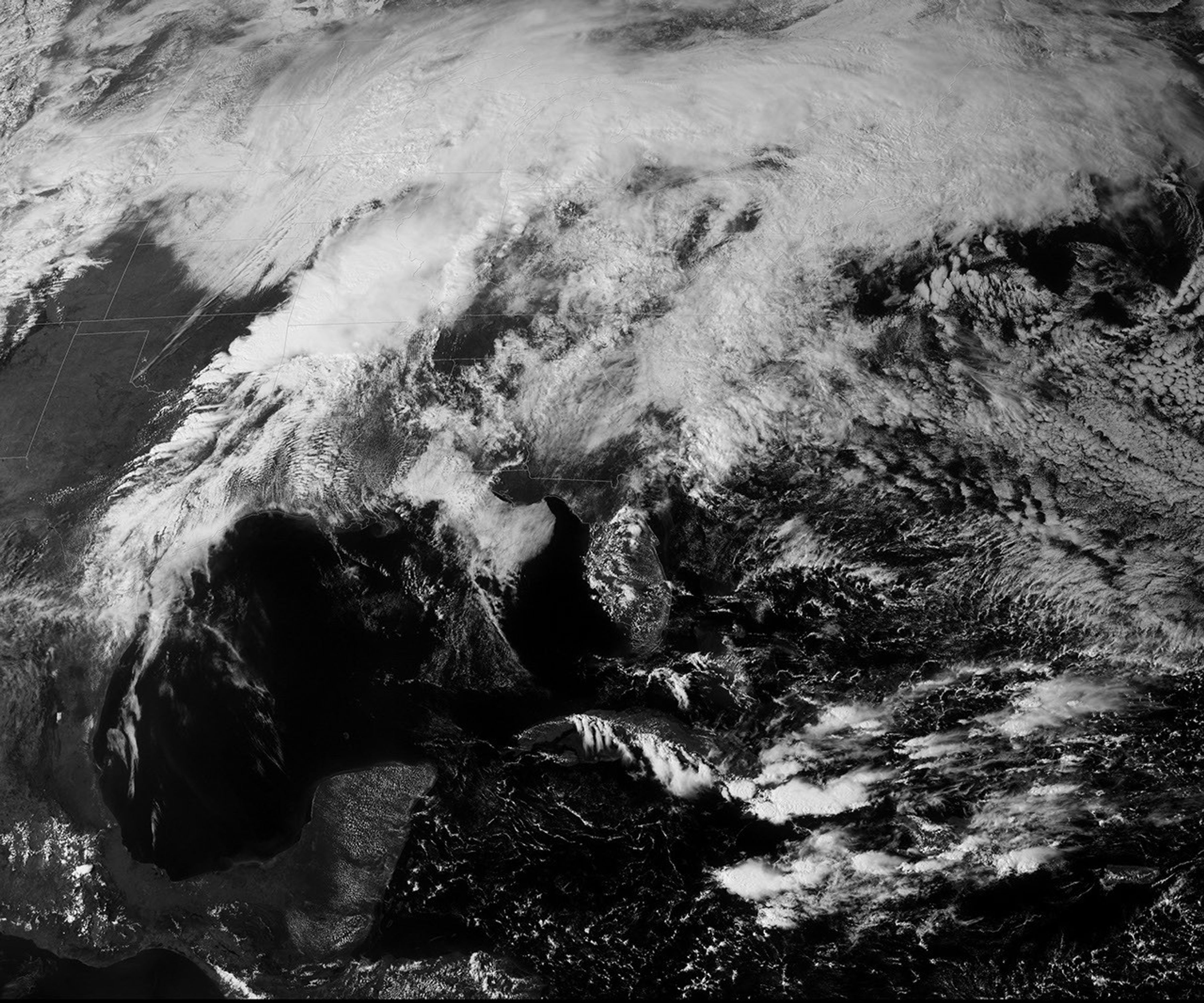
You can almost see the clash between warm, wet tropical air and cold, dry polar air in this GOES satellite image taken at 3:02 p.m. Central Daylight Time on March 31, 2008. Ferocious thunderstorms roiled across the Midwest on March 31, dropping hail and flood-inducing rain and battering the region with strong winds and tornadoes. As this image and the accompanying animation show, the storm moved northeast across the middle of the United States throughout the day.
The storm formed in the violent collision between warm air that had settled over the area from the Gulf of Mexico and a strong cold front. The leading edge of the mass of cold, dry air pushed the warm, moist air high into the atmosphere, where it condensed into rain clouds. Towering clouds stretch in a thin line along the northern edge of the storm, their shadows giving the otherwise smooth mass of clouds a bumpy texture. Strong thunderstorms often form along the edge of a cold front, and the line in this image corresponds with some of the most severe weather observed on March 31. The National Weather Service confirmed nine tornadoes in Missouri and one in Oklahoma along this line.
The storm also brought heavy rain to a region still recovering from widespread flooding. The storm helped Springfield, Missouri, set a new record for rainfall received during March, the second record-breaking month in a row for the city, said the National Weather Service.
- References
- National Climatic Data Center. (2008, February 27). U.S. tornado climatology. NOAA Satellite and Information Service. Accessed April 3, 2008.
- National Weather Service Weather Forecast Office, Norman, Oklahoma. (2008, March 31). Results of the tornado damage survey in northwest Oklahoma City. National Oceanic and Atmospheric Administration. Accessed April 3, 2008.
- National Weather Service Weather Forecast Office, Springfield, Missouri. (2008, April 2). March 31, 2008, tornadoes, severe storms, and flooding. National Oceanic and Atmospheric Administration. Accessed April 3, 2008.
References & Resources
- References
- National Climatic Data Center. (2008, February 27). U.S. tornado climatology. NOAA Satellite and Information Service. Accessed April 3, 2008.
- National Weather Service Weather Forecast Office, Norman, Oklahoma. (2008, March 31). Results of the tornado damage survey in northwest Oklahoma City. National Oceanic and Atmospheric Administration. Accessed April 3, 2008.
- National Weather Service Weather Forecast Office, Springfield, Missouri. (2008, April 2). March 31, 2008, tornadoes, severe storms, and flooding. National Oceanic and Atmospheric Administration. Accessed April 3, 2008.
NASA image and animation by Robert Simmon, based on data from the GOES Project Science Office. Caption by Holli Riebeek.