


Days after Typhoon Doksuri slammed the Philippines, Taiwan, and China, another strong storm was threatening more damage in the Western Pacific region. Typhoon Khanun was intensifying over the Pacific Ocean when the Visible Infrared Imaging Radiometer Suite (VIIRS) on the NOAA-20 satellite captured this image at 1:20 p.m. Japan Standard Time (4:20 Universal Time) on July 31, 2023.
Models from the day before showed Khanun’s trajectory pointed at China’s coast, south of Shanghai, but moving more slowly than previously forecast. The typhoon was expected to slow or stall near Okinawa, Japan, and stay offshore of China for several days. By 9 p.m. Japan Standard Time (12:00 Universal Time) on July 31, Khanun had reached category 4 on the Saffir-Simpson scale, with sustained winds of 130 miles per hour, reported Weather Underground.
Okinawa is bracing for a category 2 or stronger storm at its closest passage, expected sometime around August 1, bringing heavy rain, strong winds, and storm tides. China could see a lower-intensity landfall several days later as Khanun creeps onward. Some models show it turning away from land after passing Okinawa. Still, China’s Zhejiang Province activated a Level IV emergency response—the lowest in its system—on July 30 in anticipation of storm surge.
The region has had little time to recover from the impacts of Typhoon Doksuri, which struck heavily populated areas south of Khanun’s path. The image below, acquired on July 27 by VIIRS on NOAA-20, shows the typhoon after it lashed the Philippines and before it reached China.
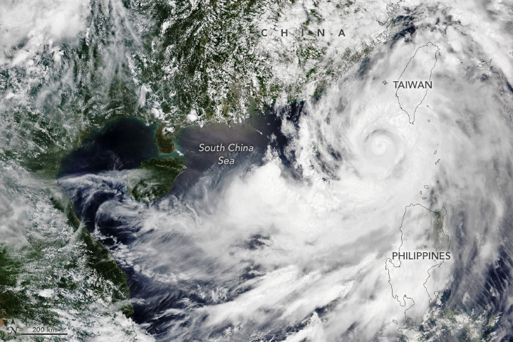
Doksuri caused dozens of deaths in the Philippines, according to news reports, resulting from landslides, flooding, and a capsized passenger ship. Thousands more people were displaced. On Taiwan, the storm dropped up to 700 millimeters (28 inches) of rain in some areas.
The typhoon made landfall near the large cities of Xiamen and Quanzhou, China, on July 28 at about 10 a.m. local time. More than 400,000 people evacuated from coastal areas. From there, the relentless rains from Doksuri continued. The storm proceeded north in the ensuing days and caused severe flooding in Beijing, approximately 1,600 kilometers (1,000 miles) away from Quanzhou. The city recorded 177 millimeters (7 inches) of rain, and one station in the outlying district of Mentougou logged 580 millimeters (23 inches), according to news reports. The deluge damaged infrastructure and spurred evacuations and rescues.
References & Resources
- The Associated Press (2023, July 28) Typhoon Doksuri makes landfall in China after bringing deadly landslides to Philippines. Accessed July 31, 2023.
- Reuters (2023, July 31) Extreme rain in Beijing after typhoon turns roads into rivers, kills two. Accessed July 31, 2023.
- The Watchers (2023, July 30) Typhoon “Doksuri” slams China with record rains after lashing Taiwan and leaving 41 dead in the Philippines. Accessed July 31, 2023.
- Weather Underground (2023, July 31) TYPHOON KHANUN. Accessed July 31, 2023.
- Yale Climate Connections (2023, July 28) One down, another coming: China faces two typhoons in one week. Accessed July 31, 2023.
NASA Earth Observatory images by Wanmei Liang, using VIIRS data from NASA EOSDIS LANCE , GIBS/Worldview , and the Joint Polar Satellite System (JPSS). Story by Lindsey Doermann .


