
After two months of eruptions and six months of quakes and tremors, the underwater volcano off the coast of El Hierro appears to be quieting down. A mass of new crust has been building by tens to perhaps a hundred meters, but it is still nowhere near rising above the ocean surface and extending the Canary Island chain.
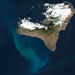
The Advanced Land Imager (ALI) on NASA’s Earth Observing-1 (EO-1) satellite captured this natural-color image of the island and its offshore eruption on December 16, 2011. The eruption is located about one kilometer south-southwest of the town of La Restinga.
The milky green swirls in the Atlantic Ocean are a volcanic brew of steaming lava fragments, bits of rock, heated gas, and other debris that are carried to the west and north by currents. Meanwhile, tremors have been occurring on the north side of the island at depths of 17 to 23 kilometers. Red circles mark the locations of three tremors reported on December 18. The white puffs over the island are clouds, not volcanic emissions.
A swarm of seismic rumblings first began under the island in July 2011, and a submarine eruption was detected in mid-October. But in recent weeks, carbon dioxide emissions have been decreasing, a sign that the supply of magma is decreasing, according to geologist and blogger Erik Klimetti. The number of tremors also has been decreasing, though activity at the site has waxed and waned several times since the event began.
El Hierro is a shield volcano growing along the southwestern edge of the ancient El Golfo volcano. El Golfo collapsed about 130,000 years ago, but the ruddy brown and rugged terrain of the island attests to many years of volcanism in the area. El Hierro last erupted in 1793, according to some historical records, and the area has the greatest concentration of young vents in the Canary Islands.
To view video clips of the seas near the eruption, visit the INVOLCAN web site.
References & Resources
- Europapress (2011, December 18) La evolución del tremor en El Hierro indica que la erupción sigue su curso. Accessed December 20, 2011.
- Klimetti, Erik (2011) Eruptions Blog: El Hierro. Wired Science. Accessed December 20, 2011.
- Smithsonian/U.S. Geological Survey Global Volcanism Program (2011, December 13) Weekly Volcanic Activity Report. Accessed December 20, 2011.
NASA Earth Observatory image created by Jesse Allen and Robert Simmon, using EO-1 ALI data provided courtesy of the NASA EO-1 team. Caption by Michael Carlowicz.