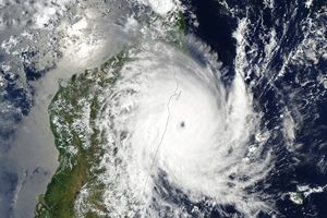
Tropical Cyclone Carlos strengthened after moving back over the ocean on February 24, 2011. The U.S. Navy’s Joint Typhoon Warning Center (JTWC) reported that, as of 11:00 p.m. Western Australia time on February 24, Carlos was located roughly 340 nautical miles (630 kilometers) west-southwest of Learmonth. The storm had maximum sustained winds of 65 knots (120 kilometers per hour) and gusts up to 80 knots (150 kilometers per hour).
The Moderate Resolution Imaging Spectroradiometer (MODIS) on NASA’s Aqua satellite captured this natural-color image around 2:15 p.m. local time on February 24, 2011. Sporting a circular shape, Carlos hovers off the coast of Western Australia.
Carlos had been forecast to intensify after traveling away from land, but the storm did so faster than expected. As a result, the forecast for Carlos changed, the JTWC reported. Forecasters anticipated that it would remain strong despite less favorable conditions, and would weaken more slowly than originally predicted.
References & Resources
- Joint Typhoon Warning Center. (2011, February 24). Tropical Cyclone 15S (Carlos) Warning. Accessed February 24, 2011.
NASA image by Jeff Schmaltz, MODIS Rapid Response Team at NASA GSFC. Caption by Michon Scott.


