


![Request for Information – Potential [Placeholder for Prize]](https://assets.science.nasa.gov/dynamicimage/assets/science/psd/solar/2023/09/s/solarsystem_0.jpg?w=1024)


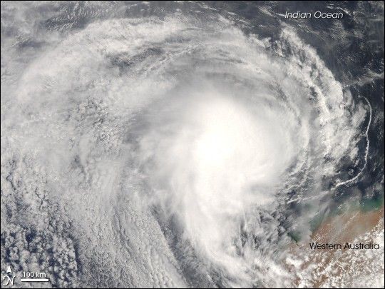
Tropical Cyclone Melanie had an impressive appearance on December 30, 2007, as the storm swirled off the coast of Western Australia. Fortunately, the storm, which had sustained winds of 125 kilometers per hour (70 miles per hour), did not come ashore, and it brought only moderate storm conditions to the sparsely populated coast.
The Moderate Resolution Imaging Spectroradiometer (MODIS) on NASA’s Aqua satellite acquired this photo-like image at 2:10 p.m. local time (6:10 UTC) on December 20, 2007. The storm had basic spiral structure, with long arms of cloud wrapping around its center in a clockwise direction (characteristic of Southern Hemisphere cyclones). However, the storm system lacked a distinct eye, one indicator that it was not a powerful storm.
The high-resolution image provided above is at MODIS’ full spatial resolution (level of detail) of 250 meters per pixel. The MODIS Rapid Response System provides this image at additional resolutions.
You can also download a 250-meter-resolution KMZ file of Tropical Cyclone Melanie suitable for use with Google Earth.
References & Resources
NASA image by Jeff Schmaltz, MODIS Rapid Response Team, Goddard Space Flight Center.


