![Request for Information – Potential [Placeholder for Prize]](https://assets.science.nasa.gov/dynamicimage/assets/science/missions/a-step/FFR_Earth_Background_20251120%20.png?w=1024)


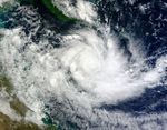
Zane formed as a tropical storm over the southwestern Pacific Ocean on April 30, 2013, and strengthened into a cyclone the same day. The U.S. Navy’s Joint Typhoon Warning Center (JTWC) reported that the storm had maximum sustained winds of 60 knots (110 kilometers per hour) and gusts up to 75 knots (140 kilometers per hour). The storm was expected to pass over northeastern Australia and the Gulf of Carpentaria between May 1 and 3.
The Moderate Resolution Imaging Spectroradiometer (MODIS) on NASA’s Terra satellite captured this natural-color image on April 30, 2013. Zane hovered over the Coral Sea between Papua New Guinea and Australia.
The JTWC forecast that as Zane traveled westward, it would gain strength, reaching sustained wind speeds of 85 knots (160 kilometers per hour) and gusts of 105 knots (195 kilometers per hour) around May 1. Afterwards, wind speeds were expected to drop.
References & Resources
- Joint Typhoon Warning Center Accessed April 30, 2013.
- Unisys (2013, April 30) Zane Tracking Information. Accessed April 30, 2013.
NASA image courtesy Jeff Schmaltz, LANCE/EOSDIS MODIS Rapid Response Team at NASA GSFC. Caption by Michon Scott.