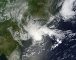

The Atlantic hurricane season officially starts June 1, but the 2012 season’s first storm arrived a little early. On May 19, 2012, the U.S. National Hurricane Center (NHC) reported that Tropical Storm Alberto had formed off the South Carolina coast. The Moderate Resolution Imaging Spectroradiometer (MODIS) on NASA’s Terra satellite captured this natural-color image the same day.
Although Alberto sported the spiral shape typical of tropical storms, it lacked a distinct eye, and had not reached hurricane strength. Storm clouds did, however, extend far inland over the Carolinas. As of 5 p.m. Eastern Daylight Time (EDT) May 19, the storm packed maximum sustained winds of 45 miles (75 kilometers) per hour. An update issued later that evening indicated wind speeds of 60 miles (95 kilometers) per hour, and wind speeds were at 50 miles (85 kilometers) per hour the next morning. As of 5 p.m. EDT May 20, the NHC discontinued the tropical storm watch along the U.S. East Coast.
References & Resources
- National Hurricane Center. (2012, May 20). Tropical Storm Alberto Advisory Archive. Accessed May 20, 2012.
NASA image courtesy Jeff Schmaltz, MODIS Rapid Response Team, Goddard Space Flight Center. Caption by Michon Scott.