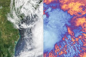
Tropical Storm Beryl formed in the northwestern Atlantic on July 18, 2006, roughly 200 kilometers (120 miles) southeast of North Carolina’s Outer Banks. The tropical depression gradually gathered just enough power to reach storm status and to become the second named storm system of the 2006 Atlantic hurricane season. As of July 19, it had done little more than this, gaining only slightly more strength and heading north towards Long Island. Forecasts at that time called for it to continue its slow and gradual building for a few more days, but to curve away to the east well before getting close to land. Forecasters were not expecting the storm to affect any of the United States’ coastal cities.
This photo-like image was acquired by the Moderate Resolution Imaging Spectroradiometer (MODIS) on the Aqua satellite on July 18, 2006, at 2:10 p.m. local time (18:10 UTC). The storm had a very basic round shape embedded within a larger train of clouds associated with a cold front over the Atlantic Ocean. Sustained winds in the storm system were estimated to be around 65 kilometers per hour (40 miles per hour) around the time the image was captured, according to the University of Hawaii’s Tropical Storm Information Center.
References & Resources
NASA image by Jesse Allen, Earth Observatory, using data obtained from the MODIS Rapid Response team.