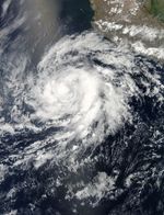
On May 20, 2012, a tropical depression formed over the eastern Pacific Ocean, about 525 miles (845 kilometers) south of Acapulco, Mexico. The depression strengthened into a tropical storm on May 22, and became a hurricane on May 23. At 5:00 a.m. Pacific Daylight Time (PDT) on May 24, 2012, the U.S. National Hurricane Center (NHC) reported that Hurricane Bud was located roughly 315 miles (510 kilometers) south-southwest of Manzanillo, Mexico.
The Moderate Resolution Imaging Spectroradiometer (MODIS) on NASA’s Aqua satellite captured this natural-color image around 1:30 p.m. PDT on May 23, several hours before Tropical Storm Bud strengthened into a hurricane.
As of 5:00 a.m. PDT on May 24, the NHC reported, Bud had maximum sustained winds of 90 miles (150 kilometers) per hour, and was moving slowly toward the north-northeast. Bud was expected to approach the southwestern coast of Mexico late in the day on May 25. A hurricane watch was in effect for the coast of Mexico from Punto San Telmo to Cabo Corrientes.
References & Resources
- National Hurricane Center. (2012, May 24). Hurricane Bud Advisory Archive. Accessed May 24, 2012.
NASA image courtesy Jeff Schmaltz, MODIS Rapid Response Team, Goddard Space Flight Center. Caption by Michon Scott.