


![Request for Information – Potential [Placeholder for Prize]](https://assets.science.nasa.gov/dynamicimage/assets/science/psd/solar/2023/09/s/solarsystem_0.jpg?w=1024)


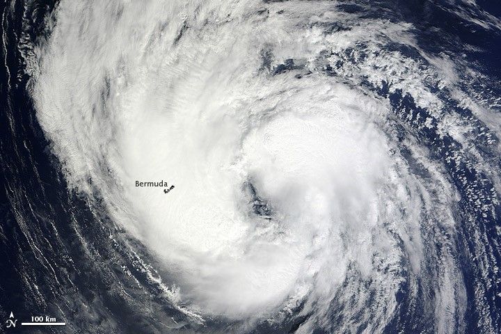
On September 9, 2012, Leslie was once again a tropical storm after spending several days as a hurricane. The storm brought rain and wind to Bermuda and had the potential to bring severe weather to Newfoundland in the coming days.
The Moderate Resolution Imaging Spectroradiometer (MODIS) on NASA’s Terra satellite captured this natural-color image on September 9. Storm clouds extended over Bermuda (outlined in black). The Associated Press reported that Leslie forced the cancellation of flights, but did not cause major damage or injuries.
The same day that MODIS acquired this image, the U.S. National Hurricane Center (NHC) reported that Leslie had maximum sustained winds of 60 miles (95 kilometers) per hour. Wind speeds remained the same on August 10, when the NHC reported a hurricane watch for parts of Newfoundland. Leslie was moving toward the north-northeast at about 17 miles (28 kilometers) per hour, and was expected to pass over eastern Newfoundland on the morning of September 11.
References & Resources
- National Hurricane Center. (2012, September 10) Hurricane Leslie Advisory Archive. Accessed September 10, 2012.
- Roberts, E. Associated Press. (2012, September 9) Tropical Storm Leslie slowly moves past Bermuda. ABC News. Accessed September 10, 2012.
NASA image courtesy Jeff Schmaltz, LANCE MODIS Rapid Response Team, Goddard Space Flight Center. Caption by Michon Scott.


