Editor's Note: Today’s caption is the answer to Earth Observatory’s monthly satellite puzzler.
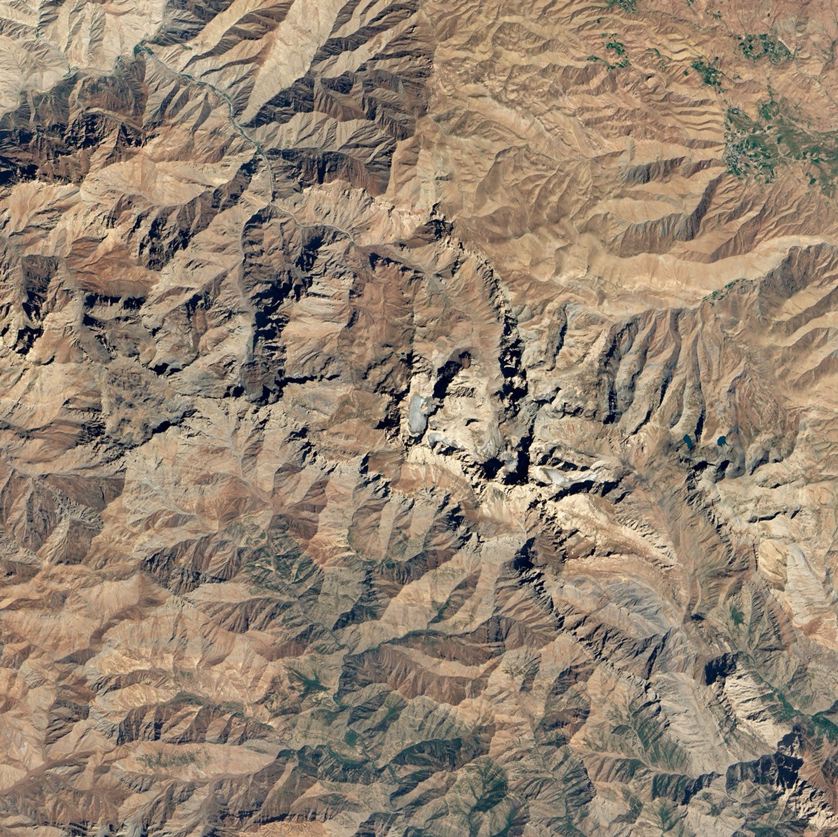
When it comes to glaciers, Turkey probably isn’t the first country that comes to mind. However, numerous peaks in the rugged mountains of eastern Turkey are high enough and cold enough to sustain year-round ice. About two-thirds of Turkey’s glaciers lie within the Taurus Mountains, a chain of peaks that stretch from the Mediterranean coast toward the borders of Iran and Iraq. The southeastern portion of the range supports Turkey’s largest glaciers.
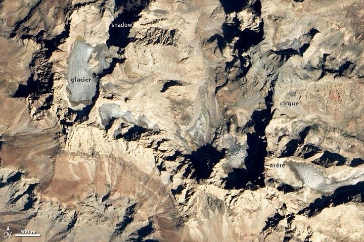
On September 9, 2012, at 10:30 a.m. local time, the Advanced Land Imager (ALI) on NASA’s Earth Observing-1 (EO-1) satellite acquired this view of glaciers near Mount Uludoruk, the second tallest mountain in Turkey. At 4,135 meters (13,566 feet) Uludoruk trails only Mount Ararat.
Uludoruk’s glaciers are located within bowl-shaped hollows called cirques that are etched into the sides of steep ridges. The features form when snow piles up in a depression, accumulates into a glacier, and broadens as it spills down the slopes into adjacent valleys.
The tan and red colors that dominate the image are rock outcrops, which offer clues to geologists about the complex tectonic processes that built the mountains. The black blotches are shadows cast by the thin, serrated ridges of rock— called arêtes—that crisscross the image. (The image was taken in the morning in the northern hemisphere, so the shadows point northwest.) Arêtes form when alpine glaciers grind away at mountainsides long enough to leave knife-like ridges protruding between parallel valleys. When three or more glaciers erode toward each other, they can transform arêtes into dramatic pyramid-shaped peaks, such as the Matterhorn.
Geologists and explorers have surveyed Uludoruk’s glaciers from the ground for more than a century. In 1901, Major F.R. Maunsell, a British officer, published one of the first photographs of the mountain’s glaciers in a Royal Geographic Society journal. In 1937, geologists reported the terminus of the glacier in Maunsell’s grainy photograph was at a height of about 2,600 meters (8,500 feet). By the 1950s, the same tongue of ice had retreated to 2,900 meters (9,500 feet).
A new analysis of satellite imagery led by Fatih University’s Mehmet Sarikaya, which will be published in 2013, concluded that the glaciers have continued their retreat since the 1950s. Sarikaya found that Uludoruk glacier retreated 12 meters (39 feet) per year between 1948 and 2009.
References & Resources
- Ciner, A. (2004, May 20). Turkish glaciers and glacier deposits. Quaternary Glaciations.
- Kurter, A. (1988, May 20). Glaciers of the Middle East and Africa: Turkey (PDF) U.S. Geological Society Professional Paper.
- Sarikaya, M.A. (2013, in press). Present glaciers of Turkey. Praxis-Springer. ISBN: 978-3-540-79817-0
- Sarikaya, M.A. (2011). Quaternary glaciations of Turkey. Developments in Quaternary Science.
NASA Earth Observatory image by Robert Simmon, using EO-1 ALI data from the NASA EO-1 team. Caption by Adam Voiland. Congratulations to Britton, Dakota Steve, Alev Akyildiz, and Eric Jeffrey for being some of our first readers to solve the puzzler.